


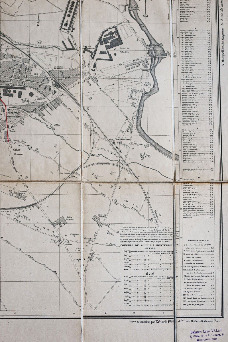


"Monumental Plan Of Montpellier"
Plan original réalisé en 1896. A. Kruger architecte de la ville.Dressé sous l’administration de Monsieur Castets maire de la ville.
Entoilé d’époque, replié en 24 sections.
Trace de pli angulaire dans les 2 coins de la marge supérieure, n’atteignant pas le plan.
Bon état.
Format plan : 106 x 101 cm de largeur.
Légende manuscrite en rouge indiquant le quartier de Celleneuve et le futur tracé du tramway qui sera réalisé en 1897.
Un tracé manuscrit complète le plan dans la marge supérieure indiquant Castelnau.
Table alphabétique des rues, places et faubourgs encadrant le plan. Tableaux avec Horaires du lever et coucher du soleil. Tampon dans la marge inférieure de la librairie Valat à Montpellier.
Peu courant.
Vous pouvez consulter l’ensemble des cartes, livres et gravures disponibles sur votre région en cliquant sur le lien de notre site internet spécialisé en archives anciennes géographiques :
https://cartes-livres-anciens.com/categorie-produit/cartes-geographiques-anciennes-original-antique-maps/france/languedoc-roussillon/
Règlement sécurisé par carte bancaire sur notre site internet en cliquant sur le lien ci-dessous :
https://cartes-livres-anciens.com/produit/cartes-geographiques-anciennes-original-antique-maps/france/languedoc-roussillon/plan-monumental-de-montpellier/
Toutes nos cartes et gravures sont accompagnées d’un certificat d’authenticité.
Original plan made in 1896. A. Kruger, city architect. Drawn up under the administration of Mr. Castets mayor of the city. Vintage canvas, folded in 24 sections. Angular crease trace in the 2 corners of the upper margin, not reaching the plan. Good condition. Flat format: 106 x 101 cm wide. Handwritten legend in red indicating the district of Celleneuve and the future route of the tramway which will be carried out in 1897. A handwritten line completes the plan in the upper margin indicating Castelnau. Alphabetical table of streets, squares and suburbs framing the plan. Tables with sunrise and sunset times. Stamp in the lower margin of the Valat bookstore in Montpellier. Uncommon. You can consult all the maps, books and engravings available in your region by clicking on the link of our website specializing in ancient geographical archives: https://cartes-livres-anciens.com/categorie-produit/cartes-geographiques -anciens-original-antique-maps/france/languedoc-roussillon/ Secure payment by credit card on our website by clicking on the link below: https://cartes-livres-anciens.com/produit/cartes-geographiques -anciens-original-antique-maps/france/languedoc-roussillon/plan-monumental-de-montpellier/ All our maps and engravings are accompanied by a certificate of authenticity.


 Le Magazine de PROANTIC
 TRÉSORS Magazine
 Rivista Artiquariato