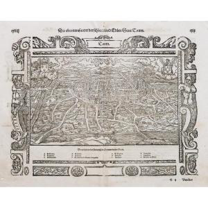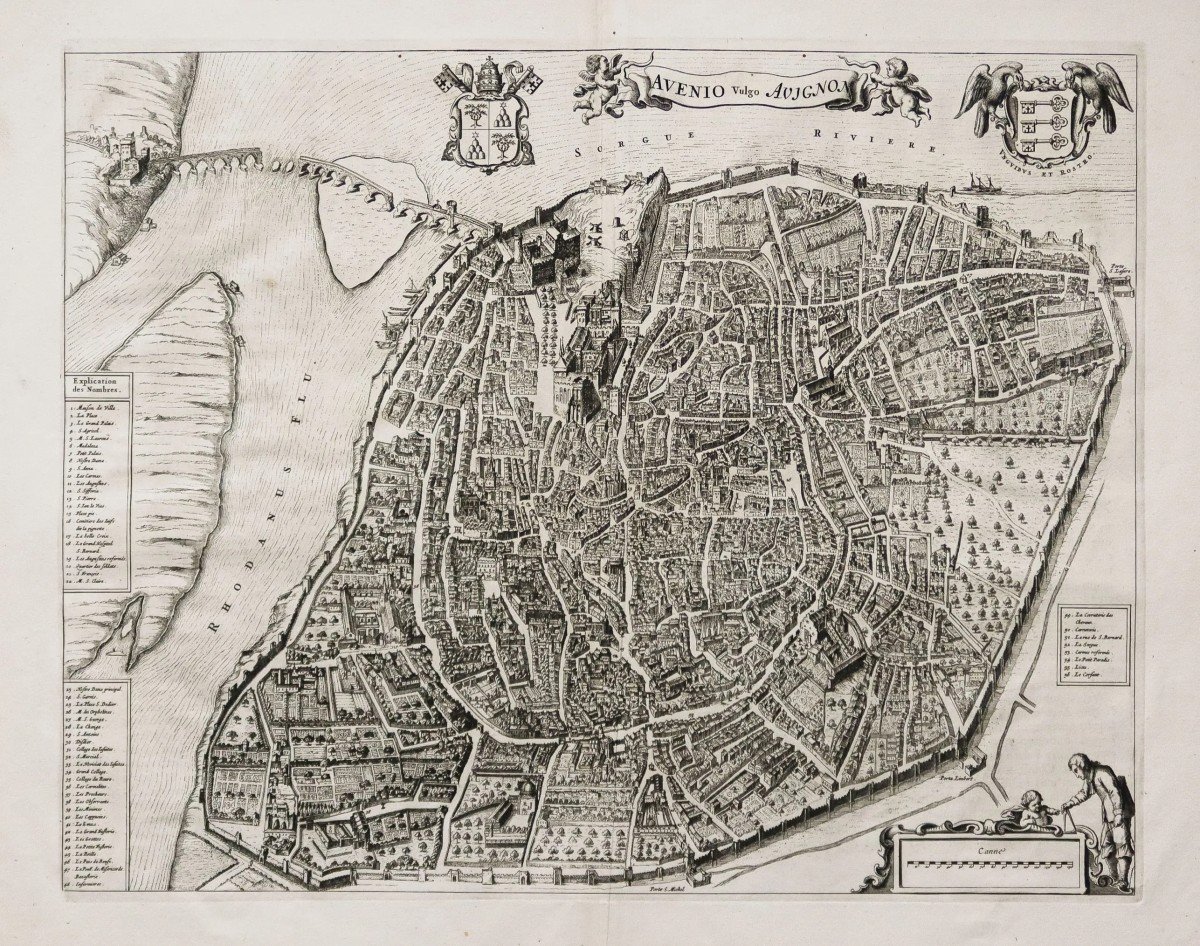
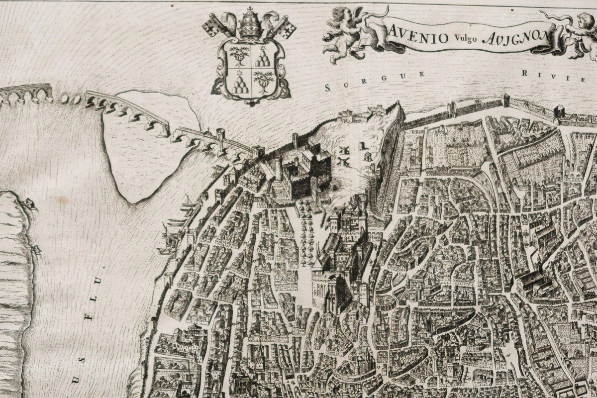
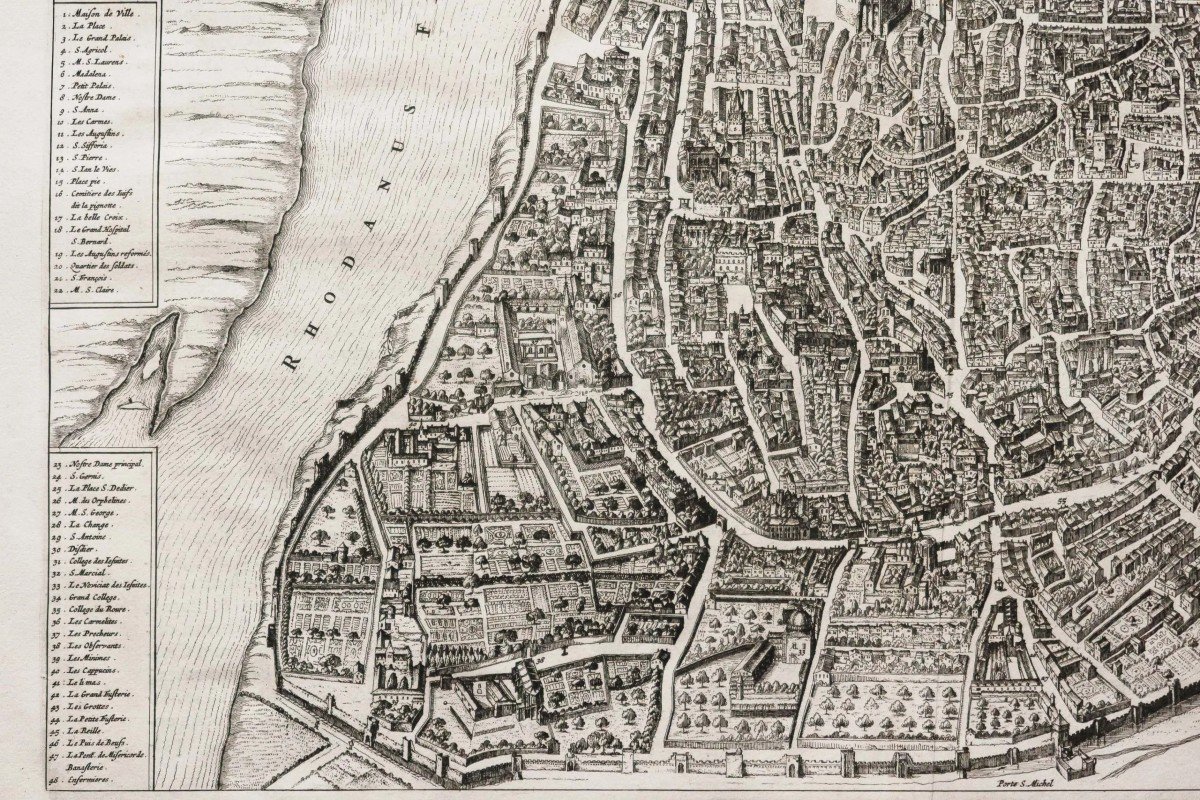
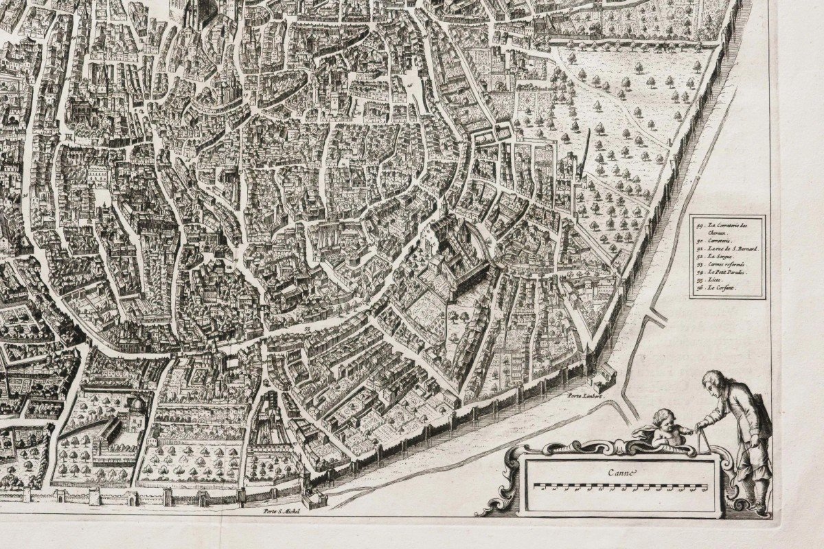
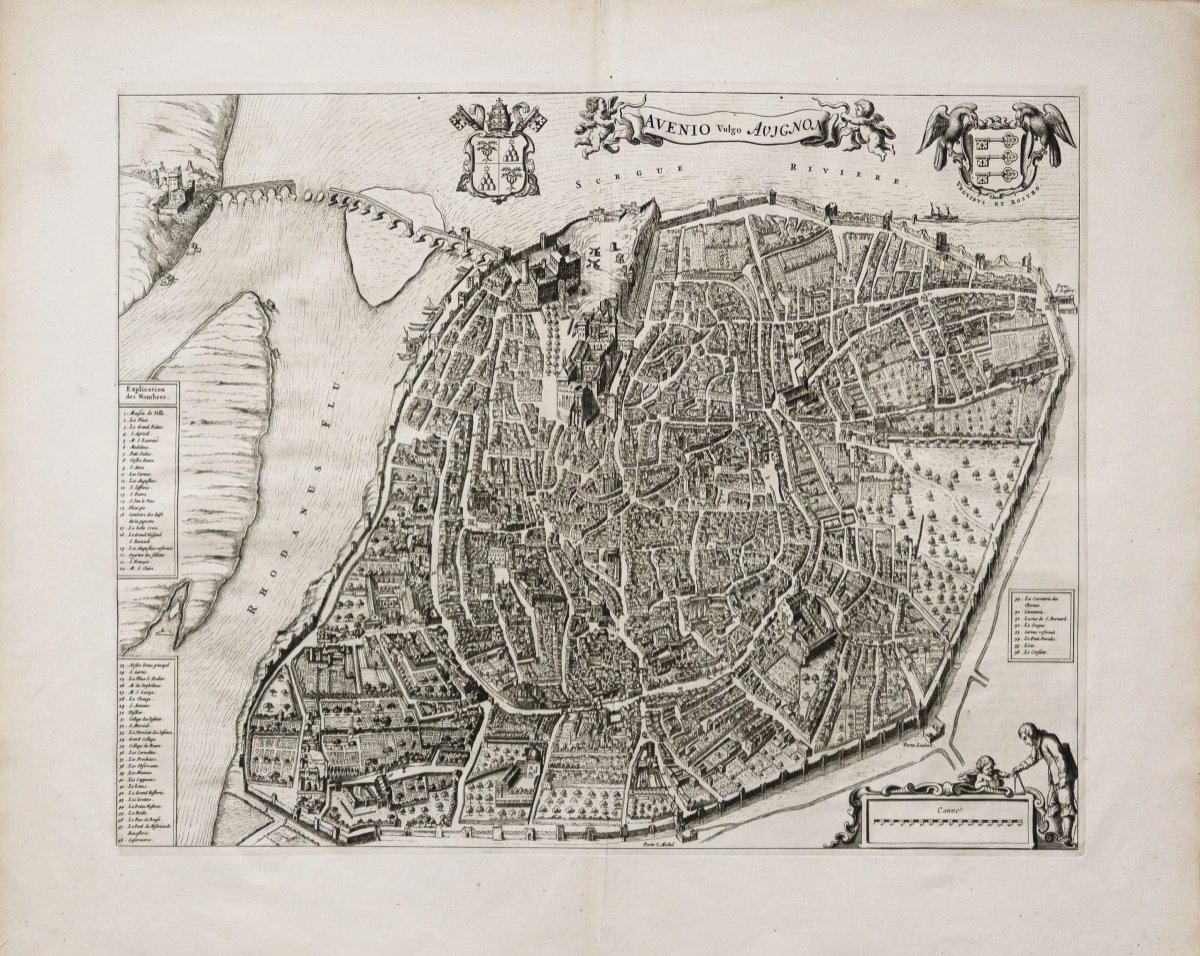


Antique Plan Of Avignon Original
Artist: Blaeu
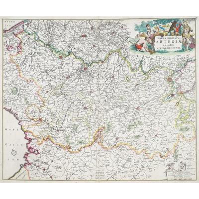
Epreuve originale réalisée en 1663. Joan Blaeu éditeur.
Fines rousseurs dans la rivière du Rhône.
Texte explicatif en latin au verso.
Très bon état.
Peu courant.
Format feuille : 65,5 x 55 cm.
Format gravure : 53 x 41,5 cm.
Original antique map of 1663.
Rare épreuve en premier tirage réalisée par la Maison Blaeu lors de l’édition de la collection des vues de villes d’Europe. Dans la lignée du travail de Braun et Hogenberg de la fin du 16e siècle.
Renvois de 1 à 56 indiquant les principaux lieux et monuments de la ville. Echelle des mesures. Blasons de la ville et bannière de titre tenue par 2 angelots.
Vous pouvez consulter l’ensemble des cartes et gravures disponibles sur votre région en cliquant sur le lien de notre site internet spécialisé en archives anciennes géographiques :
https://cartes-livres-anciens.com/categorie-produit/cartes-geographiques-anciennes-original-antique-maps/france/provence-cote-dazur/
Règlement sécurisé par carte bancaire sur notre site internet en cliquant sur le lien :
https://cartes-livres-anciens.com/produit/cartes-geographiques-anciennes-original-antique-maps/france/provence-cote-dazur/plan-ancien-davignon-3/
Toutes nos cartes et gravures sont accompagnées d’un certificat d’authenticité.
Au début du dix-septième siècle, Amsterdam est en train de devenir l’une des villes les plus commerçantes d’Europe, base de la Compagnie néerlandaise des Indes orientales, centre bancaire européen et du commerce du diamant. Ses habitants se distinguaient par leurs compétences intellectuelles et leur savoir-faire exceptionnel.
En cette période propice de l’histoire des provinces du Nord, Willem Janszoon Blaeu, né à Alkmaar en 1571 est formé à l’astronomie et aux sciences par Tycho Brahe, le célèbre astronome danois qui fonda une entreprise à Amsterdam en 1599 de fabrication de globes et d’instruments scientifiques. L’entreprise ne tarde pas à prendre de l’expansion, publiant des cartes, des ouvrages topographiques, des livres de cartes marines et des collections de globes. Ses premiers travaux les plus remarquables sont une carte de la Hollande (1604), une belle carte du monde (1605-06) et Het Licht der Zeevaerdt (La lumière de la navigation), un atlas marin.Au même moment, Blaeu préparait un atlas majeur destiné à inclure les cartes les plus récentes de l’ensemble du monde connu, mais la progression d’un si vaste projet reste lente, malgré l’achat onéreux de 40 cuivres de cartes de l’édition de Mercator ainsi que le fond de cuivre de la publication de cartes de Jodocus Hondius. En 1630, un volume de 60 cartes portant le titre Atlantis Annex fut publié. Cinq années se sont écoulées avant la publication des deux premiers volumes de son atlas mondial, Atlas Novus ou le Theatrum Orbis Terrarum. À la même époque, Blaeu fut nommé hydrographe de la Compagnie des Indes orientales.
En 1638, Blaeu mourut et l’entreprise passa aux mains de ses fils, Joan et Cornelis, qui poursuivirent et élargirent les ambitieux projets de leur père. Après la mort de Cornelis, Joan dirigea l’entreprise seul et une collection de cartes en 6 volumes fut finalement achevée vers 1655. La préparation d’une collection encore plus grande, Atlas Major, vit le jour et fut publié en 1662 en 9 volumes puis 11 volumes et enfin 12 volumes pour l’édition avec texte français. Cette collection réunissait près de 600 cartes double page et 3000 textes explicatifs au verso des cartes. C’était et reste l’œuvre la plus magnifique jamais réalisée en son genre ; son contenu géographique n’était peut-être pas aussi à jour ni aussi exact que son auteur l’aurait souhaité, mais toute carence dans cette direction était plus que compensée par la finesse des gravures et leurs colorations, les cartouches élaborés, les détails picturaux et héraldiques en particulier et la splendide calligraphie. En 1672, un incendie détruisit l’imprimerie de Blaeu dans la Gravenstraat et un an après, Joan Blaeu décéda. Les stocks de cartes restants furent progressivement dispersés. Certains des cuivres d’impression ont été achetés par les cartographes, F. de Wit, Schenk et Valck, avant la fermeture définitive vers 1695.Il convient de mentionner ici qu’il existe souvent une confusion entre l’aîné Blaeu et son rival Jan Jansson (Johannes Janssonius). Jusqu’en 1619, Blaeu signa souvent ses œuvres Guilielmus Janssonius ou Willems Jans Zoon, mais après cette période, il semble avoir opté pour Guilielmus ou G. Blaeu.
Original proof made in 1663. Joan Blaeu publisher. Fine foxing in the Rhone river. Explanatory text in Latin on the back. Very good state. Uncommon. Sheet size: 65.5 x 55 cm. Engraving format: 53 x 41.5 cm. Original antique map of 1663. Rare proof in first printing produced by Maison Blaeu during the edition of the collection of views of European cities. In line with the work of Braun and Hogenberg from the late 16th century. References from 1 to 56 indicating the main places and monuments of the city. Measurement scale. Coat of arms of the city and title banner held by 2 cherubs. You can consult all the maps and engravings available in your region by clicking on the link of our website specializing in ancient geographical archives: https://cartes-livres-anciens.com/categorie-produit/cartes-geographiques-anciennes -original-antique-maps/france/provence-cote-dazur/ Secure payment by credit card on our website by clicking on the link: https://cartes-livres-anciens.com/produit/cartes-geographiques-anciennes- original-antique-maps/france/provence-cote-dazur/plan-ancien-davignon-3/ All our maps and engravings are accompanied by a certificate of authenticity. At the beginning of the seventeenth century, Amsterdam was becoming one of the most commercial cities in Europe, the base of the Dutch East India Company, a center of European banking and the diamond trade. Its inhabitants were distinguished by their intellectual skills and their exceptional know-how. At this auspicious period in the history of the northern provinces, Willem Janszoon Blaeu, born in Alkmaar in 1571, was trained in astronomy and science by Tycho Brahe, the famous Danish astronomer who founded a company in Amsterdam in 1599 to manufacture globes and scientific instruments. The business soon expanded, publishing maps, topographical works, nautical chart books and globe collections. His most notable early works are a map of Holland (1604), a beautiful map of the world (1605-06) and Het Licht der Zeevaerdt (The Light of Navigation), a marine atlas. At the same time, Blaeu was preparing a major atlas intended to include the most recent maps of the whole of the known world, but progress on such a vast project remains slow, despite the expensive purchase of 40 copperplates of Mercator's edition maps as well as the background of copper from the map publication of Jodocus Hondius. In 1630, a volume of 60 maps bearing the title Atlantis Annex was published. Five years passed before the publication of the first two volumes of his world atlas, Atlas Novus or the Theatrum Orbis Terrarum. At the same time, Blaeu was appointed hydrographer of the East India Company. In 1638 Blaeu died and the business passed into the hands of his sons, Joan and Cornelis, who continued and expanded their father's ambitious plans. After Cornelis' death, Joan ran the business alone and a 6-volume collection of maps was finally completed around 1655. Preparation for an even larger collection, Atlas Major, saw the light of day and was published in 1662 in 9 volumes then 11 volumes and finally 12 volumes for the edition with French text. This collection brought together nearly 600 double-page cards and 3,000 explanatory texts on the back of the cards. It was and remains the most magnificent work of its kind ever made; its geographical content was perhaps not as up-to-date or as exact as its author would have wished, but any deficiency in this direction was more than compensated for by the fineness of the engravings and their colorings, the elaborate cartouches, the pictorial details and heraldry in particular and the splendid calligraphy. In 1672 a fire destroyed Blaeu's printing press in the Gravenstraat and a year later Joan Blaeu died. The remaining stocks of cards were gradually dispersed. Some of the printing coppers were bought by the cartographers, F. de Wit, Schenk and Valck, before the final closing around 1695.It should be mentioned here that there is often confusion between the elder Blaeu and his rival Jan Jansson (Johannes Janssonius). Until 1619 Blaeu often signed his works Guilielmus Janssonius or Willems Jans Zoon, but after this period he seems to have opted for Guilielmus or G. Blaeu.
1 500 €
Period: 17th century
Style: Other Style
Condition: Excellent condition
Material: Paper
Reference (ID): 1129451
Availability: In stock
Print