


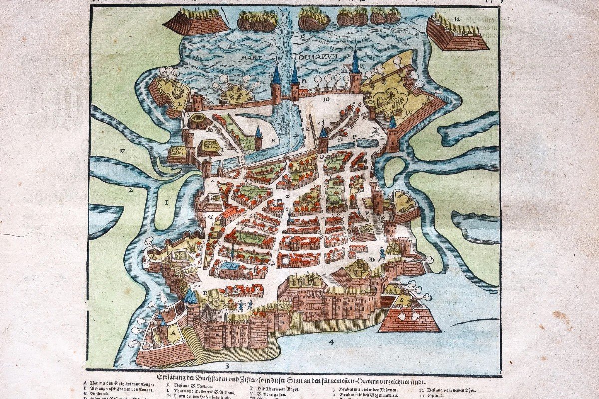


"Old Map Of La Rochelle"
Epreuve originale réalisée vers 1570. Sebastian Münster cartographe.Beaux coloris aquarelle.
Petites rousseurs dans les marges n’atteignant pas l’épreuve.
Texte en gothique au verso.
Très bon état.
Format feuille : 40 x 32 cm.
Format sujet : 26 x 24 cm.
Original antique plan of 1570.
Renvois de A à Z et de 1 à 18 situant les principaux lieux et monuments de la ville.
L’une des premières représentations gravées de la cité.
Vous pouvez consulter l’ensemble des cartes, livres et gravures disponibles sur votre région en cliquant sur le lien de notre site internet spécialisé en archives anciennes géographiques :
https://cartes-livres-anciens.com/categorie-produit/cartes-geographiques-anciennes-original-antique-maps/france/poitou-charentes/
Règlement sécurisé par carte bancaire sur notre site internet en cliquant sur le lien ci-dessous :
https://cartes-livres-anciens.com/produit/cartes-geographiques-anciennes-original-antique-maps/france/poitou-charentes/plan-ancien-de-la-rochelle-2/
Toutes nos cartes et gravures sont accompagnées d’un certificat d’authenticité.
Sebastian Munster (1488-1552) était un cosmographe et professeur d’hébreu qui enseigna à Tübingen, Heidelberg et Bâle. Il s’y installa en 1529 et y mourut de la peste en 1552. Jeune homme, Münster rejoignit l’ordre des franciscains et étudia la philosophie à Heidelberg. Il a également étudié la géographie et les mathématiques à Loewen, ainsi que l’hébreu à Fribourg.
En 1512, il est ordonné prêtre et enseigne la philosophie et la théologie à Tübingen de 1514 à 1518. À Tübingen, il poursuit également des études de géographie. Il s’installe à Bâle en 1518 et publie une grammaire hébraïque, l’un des premiers ouvrages en hébreu publié en Allemagne. En 1521, Münster s’installa de nouveau à Heidelberg, où il continua de publier des textes en hébreu et les premiers livres en araméen produits en Allemagne.
Après s’être converti au protestantisme en 1529, il reprit sa chaire d’hébreu à Bâle, où il publia son ouvrage principal en hébreu, un ancien testament en deux volumes avec une traduction en latin.
Münster était au centre d’un vaste réseau d’érudits auprès desquels il a obtenu des descriptions géographiques, des cartes et des indications territoriales.
Il publie sa première carte connue, une carte de l’Allemagne, en 1525. Trois ans plus tard, il publie un traité sur les cadrans solaires.
En 1540, il publia le « Geographia universalis vetus et nova », une édition actualisée de « Geographia » de Ptolémée. En plus des cartes ptolémaïques, Münster a ajouté 21 cartes modernes. Une des innovations de Münster consistait à inclure une carte pour chaque continent, un concept qui influencerait Ortelius et les autres premiers fabricants d’atlas. Le Geographia a été réimprimé en 1542, 1545 et 1552.
Münster est surtout connu aujourd’hui pour son Cosmographia universalis, la première description du monde en langue allemande. Il fut publié pour la première fois en 1554 pour une collection qui contenait 471 gravures sur bois et 26 cartes.
Les gravures sur bois et les cartes ont toutes influencé la pensée géographique pendant des générations.
Original proof made around 1570. Sebastian Münster cartographer. Beautiful watercolor colors. Small foxing in the margins not reaching the proof. Text in Gothic on the back. Very good state. Sheet size: 40 x 32 cm. Subject format: 26 x 24 cm. Original antique plan of 1570. References from A to Z and from 1 to 18 locating the main places and monuments of the city. One of the first engraved representations of the city. You can consult all the maps, books and engravings available in your region by clicking on the link of our website specializing in ancient geographical archives: https://cartes-livres-anciens.com/categorie-produit/cartes-geographiques -anciens-original-antique-maps/france/poitou-charentes/ Secure payment by credit card on our website by clicking on the link below: https://cartes-livres-anciens.com/produit/cartes-geographiques -anciens-original-antique-maps/france/poitou-charentes/map-ancien-de-la-rochelle-2/ All our maps and engravings are accompanied by a certificate of authenticity. Sebastian Munster (1488-1552) was a cosmographer and Hebrew teacher who taught in Tübingen, Heidelberg and Basel. He settled there in 1529 and died there of the plague in 1552. As a young man, Münster joined the Franciscan order and studied philosophy in Heidelberg. He also studied geography and mathematics at Loewen, as well as Hebrew at Fribourg. In 1512 he was ordained a priest and taught philosophy and theology in Tübingen from 1514 to 1518. In Tübingen he also pursued studies in geography. He moved to Basel in 1518 and published a Hebrew grammar, one of the first works in Hebrew published in Germany. In 1521 Münster moved back to Heidelberg, where he continued to publish Hebrew texts and the first Aramaic books produced in Germany. After converting to Protestantism in 1529, he resumed his chair of Hebrew in Basel, where he published his main work in Hebrew, a two-volume Old Testament with a Latin translation. Münster was at the center of a vast network of scholars from whom he obtained geographical descriptions, maps and territorial indications. He published his first known map, a map of Germany, in 1525. Three years later he published a treatise on sundials. In 1540 he published the "Geographia universalis vetus et nova", an updated edition of Ptolemy's "Geographia". In addition to the Ptolemaic maps, Münster added 21 modern maps. One of Münster's innovations was to include a map for each continent, a concept that would influence Ortelius and other early atlas makers. The Geographia was reprinted in 1542, 1545 and 1552. Münster is best known today for his Cosmographia universalis, the first description of the world in the German language. It was first published in 1554 for a collection that contained 471 woodcuts and 26 maps. Woodcuts and maps have all influenced geographical thinking for generations.


 Le Magazine de PROANTIC
 TRÉSORS Magazine
 Rivista Artiquariato