


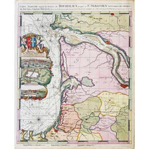


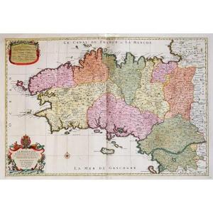
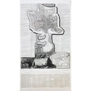
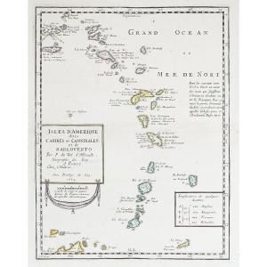
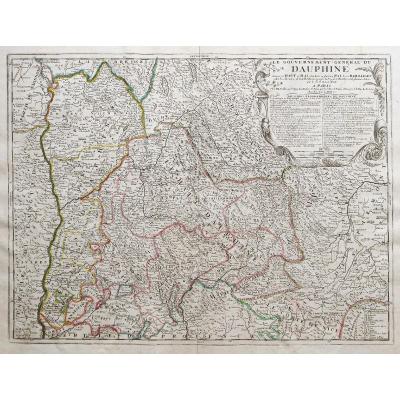
"Nautical Map Of The Bordeaux River"
Depuis la rivière de Bordeaux jusqu’à Saint Sébastien.Epreuve originale réalisée en 1693. Mortier Pierre et Romain de Hooghe éditeur.
Très beaux coloris anciens avec rehauts d’or.
Très bon état.
Format feuille : 62 x 51 cm.
Format gravure : 60 x 48 cm.
Format cadre : 79 x 67,5 cm.
L’une des plus belle carte de la côte bordelaise.
Editée au 17ème siècle pour illustré le Neptune Français, elle est enluminée de cartouches illustrant bordeaux et Royan avec un plan de Bayonne.
La carte est apparue dans une section spéciale de Neptune François de Pierre Mortier. Pour la gravure, Mortier recrute les artistes les plus qualifiés -, intitulée séparément Cartes Marines à l’Usage des Armées du Roy de la Grande Bretagne. Les neuf cartes de cette section, toutes gravées par Romeyn de Hooghe, sont décrites par Koeman comme le “type de cartographie maritime le plus spectaculaire jamais produit à Amsterdam au XVIIe siècle”.
Vous pouvez consulter l’ensemble des cartes et gravures disponibles sur votre région en cliquant sur le lien de notre site internet spécialisé en archives anciennes géographiques :
https://cartes-livres-anciens.com/categorie-produit/cartes-geographiques-anciennes-original-antique-maps/france/aquitaine-guyenne-gascogne-perigord/
Règlement sécurisé par carte bancaire sur notre site internet en cliquant sur le lien :
https://cartes-livres-anciens.com/produit/cartes-geographiques-anciennes-original-antique-maps/france/aquitaine-guyenne-gascogne-perigord/carte-marine-de-la-riviere-de-bordeaux/
Toutes nos cartes et gravures sont accompagnées d’un certificat d’authenticité.
From the Bordeaux river to San Sebastian. Original proof produced in 1693. Mortier Pierre and Romain de Hooghe publisher. Very beautiful old colors with gold highlights. Very good state. Sheet size: 62 x 51 cm. Engraving format: 60 x 48 cm. Frame size: 79 x 67.5 cm. One of the most beautiful map of the Bordeaux coast. Published in the 17th century to illustrate the French Neptune, it is illuminated with cartouches illustrating Bordeaux and Royan with a map of Bayonne. The card appeared in a special section of Neptune François by Pierre Mortier. For the engraving, Mortier recruited the most qualified artists - separately entitled Cartes Marines à l'Usage des Armées du Roy de la Grande Bretagne. The nine maps in this section, all engraved by Romeyn de Hooghe, are described by Koeman as the “most spectacular type of maritime cartography ever produced in Amsterdam in the 17th century”. You can consult all the maps and engravings available in your region by clicking on the link of our website specializing in ancient geographical archives: https://cartes-livres-anciens.com/categorie-produit/cartes-geographiques-anciennes -original-antique-maps/france/aquitaine-guyenne-gascogne-perigord/ Secure payment by credit card on our website by clicking on the link: https://cartes-livres-anciens.com/produit/cartes-geographiques- antiques-original-antique-maps/france/aquitaine-guyenne-gascogne-perigord/carte-marine-de-la-riviere-de-bordeaux/ All our maps and engravings are accompanied by a certificate of authenticity.


 Le Magazine de PROANTIC
 TRÉSORS Magazine
 Rivista Artiquariato