


"Old Geographical Maps Of The World And Continents"
Epreuves originales réalisées vers 1720. Pierre Mortier éditeur.Beaux coloris aquarelle.
Fines traces de pliures au niveau du pli central.
Bon état.
Format feuille : 59,5 x 51 cm environ.
Collection complète du monde et ses continents cartographiés par Pieter Schenk, Gérard Valck et Hubert Jaillot. Cartes particulièrement décoratives ornées de larges cartouches reprenant les attributs et personnages de chaque continents et pays.
Vous pouvez consulter l’ensemble des cartes, livres et gravures disponibles sur votre région en cliquant sur le lien de notre site internet spécialisé en archives anciennes géographiques :
https://cartes-livres-anciens.com/categorie-produit/cartes-geographiques-anciennes-original-antique-maps/monde-cartes-marines/mappemonde/
Règlement sécurisé par carte bancaire sur notre site internet en cliquant sur le lien ci-dessous :
https://cartes-livres-anciens.com/produit/cartes-geographiques-anciennes-original-antique-maps/monde-cartes-marines/mappemonde/cartes-geographiques-anciennes-du-monde-et-des-continents/
Toutes nos cartes et gravures sont accompagnées d’un certificat d’authenticité.
Monde – Mappemonde géo-hydrographique ou description générale du globe terrestre et aquatique en deux plans hémisphères où sont remarquées en général toutes les parties de la Terre et de l’eau suivant les relations les plus nouvelles. Par Gérard Valck avec privilège.
Carte ornée de 2 globes montrant les pôles, large ornementation décorative.
Renfort au dos de la marge inférieure. Très bon état. Format : 61 x 51 cm.
Afrique – Africa elaboratissima. Par Pieter Schenk.
Large cartouche de titre, orné d’un éléphant et d’un guerrier. Fait à Amsterdam avec privilège.
Très bon état. Format : 59,5 x 51 cm.
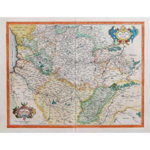
Europe – Nova Europae descriptio in regna & regiones praecipuas divisae.
L’Europe divisée en ses principaux Etats, subdivisés en leurs provinces. D’après Jaillot, par Pierre Mortier à Amsterdam, avec privilège.
Cartouche de titre décoratif avec blason aux armes de France, échelle des lieux. Très bon état. Format : 61,5 x 51 cm.
Asie – Asia accuratissime descripta. Par Schenk avec privilège.
Large cartouche de titre illustré de personnages en costume traditionnels. Animaux, une jonque, un cartouche ilustrant la Tartarie dans la partie supérieure droite.
Renfort au dos de la marge supérieure et inférieure. Lors de l’impression de la carte, le cuivre est un peu excentré et une partie de l’échelle de la marge supérieure manque. Bon état. Format : 60 x 51 cm.
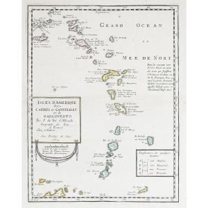
Amérique – America Septentrionalis & America méridionalis. Par Pieter Schenk avec privilège.
2 larges catouches illustrés pour l’Amérique du nord et l’Amérique du sud. Boussole. Fine trace de pli dans l’onglet central. Bon état. Format : 59,5 x 50,5 cm.
Pieter Schenk est né en Allemagne mais s’est installé à Amsterdam où il est devenu l’élève de Gerard Valck, le graveur. En 1687, il épousa la soeur de Valck. Par la suite, les familles Schenk et Valck exercèrent une longue activité, notamment auprès des vendeurs d’imprimés, des éditeurs de livres, de cartes, de dessins topographiques et architecturaux et de fabricants de globe. Bien que la famille Schenk ait produit des cartes originales, la plupart de leurs atlas consistaient en des impressions à partir de planches révisées et retravaillées à l’origine de Jansson, des Visschers, des Sansons et d’autres.
Alexis-Hubert Jaillot (1632-1712) est un ingénieur géographe et cartographe français, imprimeur à Paris, de la fin du XVIIe siècle et du début du XVIIIe siècle, au service du roi Louis XIV.
« Les plus grandes cartes du 17ème siècle »
Il publie de nombreux travaux de géographes contemporains ainsi que ses propres œuvres.
« L’Atlas François », Jaillot, 1692-1695, compilation des cartes de Nicolas Sanson (cartographe), Édité à Paris et à Amsterdam chez R. et J. Ottens.
Son travail sera continué par son fils, Bernard Jean Hyacinthe Jaillot (1673-1739), son petit-fils, Bernard Antoine Jaillot, ainsi que le beau-frère de celui-ci, Jean Baptiste-Michel Renou de Chauvigné dit Jaillot (1710-1780).
Pieter et David Mortier étaient des frères d’origine française dont les publications couvraient un vaste domaine englobant les œuvres françaises et anglaises ainsi que néerlandaises. Pieter a probablement été formé à la vente de livres et de cartes géographiques à Paris et David a passé de nombreuses années en Angleterre ; en fait, il acquit la nationalité britannique et mourut vers 1728 environ. Après le décès de Pieter, sa veuve poursuivit ses activités jusqu’à ce que leur fils, Cornelis, soit en mesure de prendre la relève. Puis, en 1721, Cornelis s’associa avec son beau-frère, Johannes Covens, pour former le célèbre nom Covens and Mortier, une entreprise qui conserva un léger changement de nom jusqu’au milieu du XIXe siècle.
Original proofs made around 1720. Pierre Mortier publisher. Beautiful watercolor colors. Fine traces of creases at the level of the central fold. Good condition. Sheet size: approximately 59.5 x 51 cm. Complete collection of the world and its continents mapped by Pieter Schenk, Gérard Valck and Hubert Jaillot. Particularly decorative cards adorned with large cartouches showing the attributes and characters of each continent and country. You can consult all the maps, books and engravings available in your region by clicking on the link of our website specializing in ancient geographical archives: https://cartes-livres-anciens.com/categorie-produit/cartes-geographiques -anciens-original-antique-maps/monde-cartes-marines/mappemonde/ Secure payment by credit card on our website by clicking on the link below: https://cartes-livres-anciens.com/produit/cartes -old-geographical-original-antique-maps/world-marine-maps/world-map/old-geographical-maps-of-the-world-and-continents/ All our maps and engravings are accompanied by a certificate of authenticity. World – Geo-hydrographic world map or general description of the terrestrial and aquatic globe in two hemisphere planes where all the parts of the Earth and the water are generally noted according to the newest relations. By Gérard Valck with privilege. Map decorated with 2 globes showing the poles, large decorative ornamentation. Reinforcement on the back of the lower margin. Very good state. Size: 61 x 51 cm. Africa – Africa elaboratissima. By Pieter Schenk. Large title cartouche, adorned with an elephant and a warrior. Made in Amsterdam with privilege. Very good state. Size: 59.5 x 51 cm. Europe – Nova Europae descriptio in regna & regiones praecipuas divisae. Europe divided into its principal States, subdivided into their provinces. After Jaillot, by Pierre Mortier in Amsterdam, with privilege. Decorative title cartouche with coat of arms of France, scale of places. Very good state. Size: 61.5 x 51 cm. Asia – Asia accuratissime descripta. By Schenk with privilege. Large title cartouche illustrated with characters in traditional costume. Animals, a junk, a cartouche illustrating Tartary in the upper right part. Reinforcement on the back of the upper and lower margin. When printing the map, the copper is a bit off center and part of the top margin scale is missing. Good condition. Size: 60 x 51 cm. America – America Septentrionalis & America méridionalis. By Pieter Schenk with privilege. 2 large cartridges illustrated for North America and South America. Compass. Fine trace of crease in the central tab. Good condition. Size: 59.5 x 50.5 cm. Pieter Schenk was born in Germany but moved to Amsterdam where he became a pupil of Gerard Valck, the engraver. In 1687 he married Valck's sister. Thereafter, the Schenk and Valck families exercised a long activity, in particular with sellers of printed matter, publishers of books, maps, topographical and architectural drawings and manufacturers of globes. Although the Schenk family produced original maps, most of their atlases consisted of printings from revised and reworked plates originally by Jansson, Visschers, Sansons and others. Alexis-Hubert Jaillot (1632-1712) was a French geographer and cartographer, printer in Paris, at the end of the 17th century and the beginning of the 18th century, in the service of King Louis XIV. “The greatest maps of the 17th century” He publishes numerous works by contemporary geographers as well as his own works. “L'Atlas François”, Jaillot, 1692-1695, compilation of maps by Nicolas Sanson (cartographer), Published in Paris and Amsterdam by R. and J. Ottens. His work will be continued by his son, Bernard Jean Hyacinthe Jaillot (1673-1739), his grandson, Bernard Antoine Jaillot, as well as his brother-in-law, Jean Baptiste-Michel Renou de Chauvigné dit Jaillot (1710- 1780). Pieter and David Mortier were brothers of French origin whose publications covered a wide area encompassing French and English as well as Dutch works. Pieter was probably trained in the sale of books and maps in Paris and David spent many years in England; in fact, he acquired British citizenship and died around 1728 or so. After Pieter's death, his widow continued in business until their son, Cornelis, was able to take over. Then, in 1721, Cornelis partnered with his brother-in-law, Johannes Covens, to form the famous name Covens and Mortier, a business which retained a slight name change until the middle of the 19th century.


 Le Magazine de PROANTIC
 TRÉSORS Magazine
 Rivista Artiquariato