Pair Of Maps Of Europe, 18th Century, Cartographer R. Bonne flag


Object description :

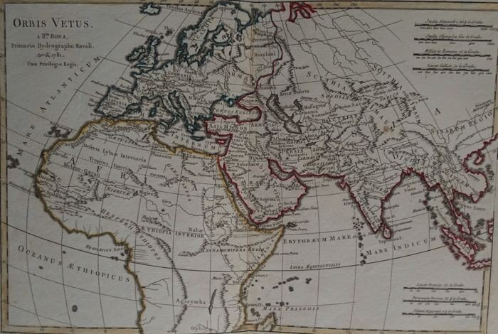
"Pair Of Maps Of Europe, 18th Century, Cartographer R. Bonne"
Pair of maps of Europe 18th century
Cartographer R. Bonne "Orbis Vetus",
The world in antiquity
April 1781
Copper engraving Image 32 x 21 cm
Full page: 37.5 x 26.5 cm
Cartographer R. Bonne

"General map of L 'Europe'
by R. Bonne cartographer
Year 1780
Copper engraving
Image 32 x 21 cm
Full page: 37.5 x 26.5 cm
All deliveries, careful shipping with insurance
Price: 230 €
credit
Artist: R. Bonne
Period: 18th century
Style: Other Style
Condition: Excellent condition

Material: Paper

Reference: 1202550
Contact Dealer
line

"Boris Marvier Antiquités" See more objects from this dealer

line

"Old Maps, Other Style"

More objects on Proantic.com
Subscribe to newsletter
line
facebook
pinterest
instagram
Boris Marvier Antiquités
General antiques & authentic
Pair Of Maps Of Europe, 18th Century, Cartographer R. Bonne
1202550-main-651aa0446d0c2.jpg
07 81 94 02 47


*We will send you a confirmation email from info@proantic.com Please check your messages, including the spam folder.

Thank you! Your submission has been received!

Oops! Something went wrong while submitting the form