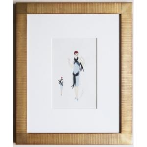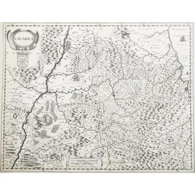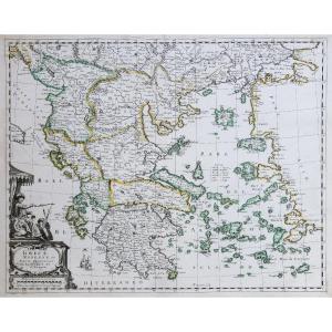


Ancient Geographical Map Of Greece
Artist: Mariette
Mariette pierre
Lorsque le 12 février 1644, Pierre Mariette acquit la majeure partie du fond de Melchior Tavernier, il était déjà un marchand d’estampes florissant. Né vers 1602 et issu, semble-t-il, d’une famille de savetiers, il avait épousé Geneviève Le Noir, fille d’un marchand libraire, et s’étant établi rue St Jacques en tant que marchand d’images, il acheta en 1637 le fond de jean Messager et devint de ce fait propriétaire de l’enseigne à L’Espérance.
Comme Tavernier, Mariette ne faisait pas du commerce des cartes sont activité principale. Il vendait des vélins enluminés, du papier en rame et surtout imprimait, sur les cinq presses de son grenier, les estampes des principaux graveurs de son époque : Rabel, François Collignon, Israël Sylvestre…
Pour une raison qui nous échappe, Mariette cessa de diffuser les cartes hollandaises sur lesquelles Tavernier avait fondé sa réussite. Il préféra les faire copier et demanda en 1646 à Abraham Peyrounin de graver une nouvelle série : Xaintonge, Béarn, perche & Blaisois, Querci, poitou.. Ces cartes restent rares.
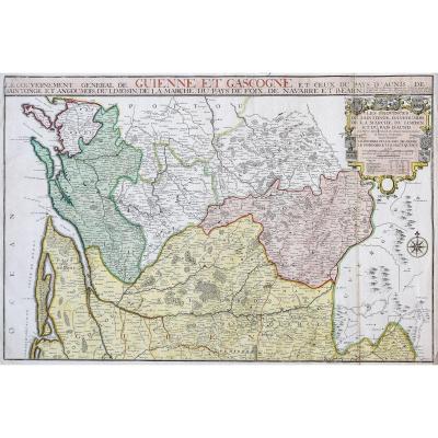
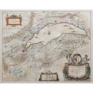
Original map engraved around 1640. Mariette publisher. Colorful boundaries of the time. Top margin corners cropped. Sheet size: 57 x 43 cm. Engraving format: 50.5 x 40 cm. Good condition. Original antique map around 1640. Modern Greece in the 17th century, Table of distances under the title block. Very pure graphics, in the tradition of 17th century French cartography. You can consult all the maps, books and engravings available in your region by clicking on the link on our website specializing in ancient geographical archives: Secure payment by credit card on our website by clicking on the link below: All our cards and engravings are accompanied by a certificate of authenticity. Mariette pierre When on February 12, 1644, Pierre Mariette acquired most of Melchior Tavernier's estate, he was already a thriving print dealer. Born around 1602 and apparently from a family of cobblers, he had married Geneviève Le Noir, daughter of a bookseller, and having established himself on rue St Jacques as a picture dealer, he bought Jean Messager's assets in 1637 and thus became the owner of the brand in L'Espérance. Like Tavernier, Mariette did not trade cards as her main activity. He sold illuminated vellums, paper in reams and above all printed, on the five presses in his attic, the prints of the main engravers of his time: Rabel, François Collignon, Israel Sylvestre... For a reason that escapes us, Mariette stopped distributing the Dutch maps on which Tavernier had based his success. He preferred to have them copied and in 1646 asked Abraham Peyrounin to engrave a new series: Xaintonge, Béarn, perche & Blaisois, Querci, poitou. These maps remain rare.
Lorsque le 12 février 1644, Pierre Mariette acquit la majeure partie du fond de Melchior Tavernier, il était déjà un marchand d’estampes florissant. Né vers 1602 et issu, semble-t-il, d’une famille de savetiers, il avait épousé Geneviève Le Noir, fille d’un marchand libraire, et s’étant établi rue St Jacques en tant que marchand d’images, il acheta en 1637 le fond de jean Messager et devint de ce fait propriétaire de l’enseigne à L’Espérance.
Comme Tavernier, Mariette ne faisait pas du commerce des cartes sont activité principale. Il vendait des vélins enluminés, du papier en rame et surtout imprimait, sur les cinq presses de son grenier, les estampes des principaux graveurs de son époque : Rabel, François Collignon, Israël Sylvestre…
Pour une raison qui nous échappe, Mariette cessa de diffuser les cartes hollandaises sur lesquelles Tavernier avait fondé sa réussite. Il préféra les faire copier et demanda en 1646 à Abraham Peyrounin de graver une nouvelle série : Xaintonge, Béarn, perche & Blaisois, Querci, poitou.. Ces cartes restent rares.
Original map engraved around 1640. Mariette publisher. Colorful boundaries of the time. Top margin corners cropped. Sheet size: 57 x 43 cm. Engraving format: 50.5 x 40 cm. Good condition. Original antique map around 1640. Modern Greece in the 17th century, Table of distances under the title block. Very pure graphics, in the tradition of 17th century French cartography. You can consult all the maps, books and engravings available in your region by clicking on the link on our website specializing in ancient geographical archives: Secure payment by credit card on our website by clicking on the link below: All our cards and engravings are accompanied by a certificate of authenticity. Mariette pierre When on February 12, 1644, Pierre Mariette acquired most of Melchior Tavernier's estate, he was already a thriving print dealer. Born around 1602 and apparently from a family of cobblers, he had married Geneviève Le Noir, daughter of a bookseller, and having established himself on rue St Jacques as a picture dealer, he bought Jean Messager's assets in 1637 and thus became the owner of the brand in L'Espérance. Like Tavernier, Mariette did not trade cards as her main activity. He sold illuminated vellums, paper in reams and above all printed, on the five presses in his attic, the prints of the main engravers of his time: Rabel, François Collignon, Israel Sylvestre... For a reason that escapes us, Mariette stopped distributing the Dutch maps on which Tavernier had based his success. He preferred to have them copied and in 1646 asked Abraham Peyrounin to engrave a new series: Xaintonge, Béarn, perche & Blaisois, Querci, poitou. These maps remain rare.
470 €
Period: 17th century
Style: Other Style
Condition: Good condition
Material: Paper
Reference (ID): 1226066
Availability: In stock
Print