


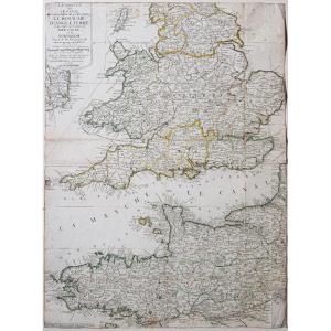


"Old Geographical Map Of The English Channel"
La Manche ou le Canal au septentrion duquel se trouve le Royaume d’Angleterre et au Midi les côtes de Bretagne et de Normandie.Epreuve originale réalisée vers 1700. Nicolas de Fer cartographe.
Limites colorées de l’époque.
Rousseurs éparses.
Coupée au cuivre.
Etat correct.
Format feuille : 70 x 51,5 cm.
Original antique map around 1700.
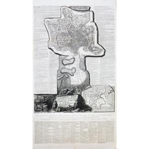
Rare carte imprimée sur grand papier en première édition gravée par H. Van Loon.
Comme intitulé : « Dans peu de temps l’autheur de cette carte donnera la partie méridionale de la France ».
Vous pouvez consulter l’ensemble des cartes, livres et gravures disponibles sur votre région en cliquant sur le lien de notre site internet spécialisé en archives anciennes géographiques :
https://cartes-livres-anciens.com/categorie-produit/cartes-geographiques-anciennes-original-antique-maps/europe/angleterre-irlande-ecosse/
Règlement sécurisé par carte bancaire sur notre site internet en cliquant sur le lien ci-dessous :
https://cartes-livres-anciens.com/produit/cartes-geographiques-anciennes-original-antique-maps/monde-cartes-marines/cartes-marines/carte-geographique-ancienne-de-la-manche/
Toutes nos cartes et gravures sont accompagnées d’un certificat d’authenticité.
De Fer Nicolas 1647 – 1720
Géographe de Sa Majesté catholique 1702 et de Monseigneur le Dauphin 1690) et géographe des Enfants royaux.
Nicolas de Fer était Fils du marchand d’estampes Antoine de Fer. Il rentra en apprentissage à l’âge de 12 ans chez le graveur Louis Spirinx en mai 1659 puis travaille avec son père jusqu’à la mort de ce dernier en juin 1673, puis avec sa mère jusqu’en 1687, année où celle-ci lui cède son commerce (8 nov. 1687).
Ingénieur et cartographe, il emploiera plusieurs graveurs qui réaliseront ses cartes marines, la cartographie des conquêtes de Louis XIV, soit plus de 600 cartes ou plans dont la France politique, administrative, ecclésiastique, hydrographique, orographique, ainsi que divers pays limitrophes.
Son œuvre marquante résultera de la réunion des cartes dans l’Atlas Curieux où le Monde représenté dans les cartes générales et particulières du Ciel et de la Terre.
The Channel or Canal to the north of which is the Kingdom of England and to the South the coasts of Brittany and Normandy. Original proof made around 1700. Nicolas de Fer cartographer. Colorful boundaries of the time. Scattered freckles. Copper cut. Good condition. Sheet size: 70 x 51.5 cm. Original antique map around 1700. Rare map printed on large paper in first edition engraved by H. Van Loon. As titled: “In a short time the author of this map will give the southern part of France”. You can consult all the maps, books and engravings available in your region by clicking on the link to our website specializing in ancient geographical archives: https://cartes-livres-anciens.com/categorie-produit/cartes-gegraphiques -Ancienes-original-antique-maps/europe/england-irlande-ecosse/ Secure payment by credit card on our website by clicking on the link below: https://cartes-livres-anciens.com/produit/cartes -geographic-old-original-antique-maps/world-marine-maps/marine-charts/old-geographic-map-of-the-Channel/ All our maps and engravings are accompanied by a certificate of authenticity. De Fer Nicolas 1647 – 1720 Geographer to His Catholic Majesty 1702 and to Monsignor the Dauphin 1690) and geographer to the Royal Children. Nicolas de Fer was son of the print dealer Antoine de Fer. He entered into an apprenticeship at the age of 12 with the engraver Louis Spirinx in May 1659 then worked with his father until the latter's death in June 1673, then with his mother until 1687, the year when she gives him his business (Nov. 8, 1687). Engineer and cartographer, he will employ several engravers who will create his marine maps, the cartography of the conquests of Louis XIV, i.e. more than 600 maps or plans including political, administrative, ecclesiastical, hydrographic, orographic France, as well as various neighboring countries. His significant work will result from the meeting of the maps in the Curious Atlas where the World represented in the general and particular maps of Heaven and Earth.


 Le Magazine de PROANTIC
 TRÉSORS Magazine
 Rivista Artiquariato