


"Old Geographical Map – Dauphiné - Provence"
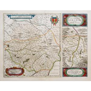
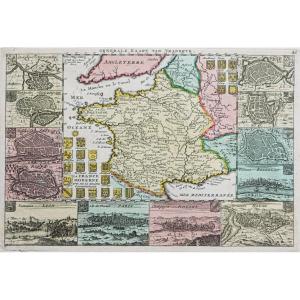
Partie du Briançonnois, du Graisivaudan, du Gapençois et l’Ambrunois dans le Dauphiné.La Principauté de Piémont, les Marquisats de Saluce et de Suze, les Comtés de Nice et d’Ast, le Montferrat…
2 épreuves originales réalisées en 1706. Hubert Jaillot cartographe.
Limites colorées de l’époque.
1 rousseur près du trait de cuivre dans la partie supérieure droite n’atteignant pas la carte.
Très bon état.
Format feuilles : 76 x 53 cm (x2)
Format gravure : 65,5 x 47 cm.
Format cuivre cartes assemblées : 65,5 x 93 cm.
Original antique map of 1706
Vous pouvez consulter l’ensemble des cartes, livres et gravures disponibles sur votre région en cliquant sur le lien de notre site internet spécialisé en archives anciennes géographiques :
https://cartes-livres-anciens.com/produit/cartes-geographiques-anciennes-original-antique-maps/europe/italie/carte-geographique-ancienne-le-dauphine/
Règlement sécurisé par carte bancaire sur notre site internet en cliquant sur le lien ci-dessous :
https://cartes-livres-anciens.com/produit/cartes-geographiques-anciennes-original-antique-maps/europe/italie/carte-geographique-ancienne-le-dauphine/
Toutes nos cartes et gravures sont accompagnées d’un certificat d’authenticité.
Alexis-Hubert Jaillot (1632-1712) est un ingénieur géographe et cartographe français, imprimeur à Paris, de la fin du XVIIe siècle et du début du XVIIIe siècle, au service du roi Louis XIV.
« Les plus grandes cartes du 17ème siècle »
Il publie de nombreux travaux de géographes contemporains ainsi que ses propres œuvres.
« L’Atlas François », Jaillot, 1692-1695, compilation des cartes de Nicolas Sanson (cartographe), Édité à Paris et à Amsterdam chez R. et J. Ottens.
Son travail sera continué par son fils, Bernard Jean Hyacinthe Jaillot (1673-1739), son petit-fils, Bernard Antoine Jaillot, ainsi que le beau-frère de celui-ci, Jean Baptiste-Michel Renou de Chauvigné dit Jaillot (1710-1780).
Part of Briançonnois, Graisivaudan, Gapençois and Ambrunois in Dauphiné. The Principality of Piedmont, the Marquisates of Saluce and Suze, the Counties of Nice and Ast, Montferrat… 2 original proofs produced in 1706. Hubert Jaillot cartographer. Colorful boundaries of the time. 1 foxing near the copper line in the upper right part not reaching the card. Very good state. Sheet format: 76 x 53 cm (x2) Engraving format: 65.5 x 47 cm. Copper assembled card format: 65.5 x 93 cm. Original antique map of 1706 You can consult all the maps, books and engravings available in your region by clicking on the link to our website specializing in ancient geographical archives: https://cartes-livres-anciens.com/produit/ Cartes-Geographies-Ancienes-Original-Antique-Maps/Europe/Italy/Carte-Gegraphique-Anciene-Le-Dauphine/ Secure payment by credit card on our website by clicking on the link below: https://cartes- Livres-Anciens.com/produit/cartes-gegraphiques-Anciens-Original-Antique-Maps/Europe/Italy/Carte-Gegraphique-Ancienne-Le-Dauphine/ All our maps and engravings are accompanied by a certificate of authenticity. Alexis-Hubert Jaillot (1632-1712) was a French geographical engineer and cartographer, printer in Paris, from the end of the 17th century and the beginning of the 18th century, in the service of King Louis XIV. “The greatest maps of the 17th century” He publishes numerous works by contemporary geographers as well as his own works. “L'Atlas François”, Jaillot, 1692-1695, compilation of maps by Nicolas Sanson (cartographer), Published in Paris and Amsterdam by R. and J. Ottens. His work will be continued by his son, Bernard Jean Hyacinthe Jaillot (1673-1739), his grandson, Bernard Antoine Jaillot, as well as his brother-in-law, Jean Baptiste-Michel Renou de Chauvigné dit Jaillot (1710- 1780).


 Le Magazine
 Rivista Artiquariato
 TRÉSORS magazine