Une partie de la marge latérale gauche rapportée anciennement.
1 pli ancien dans l’angle inférieur gauche.
Bon état.
Format feuille : 46 x 38 cm.
Format gravure : 43,5 x 32 cm.
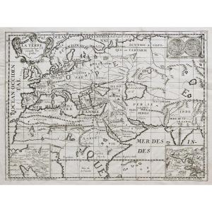
Original antique map around 1750.
Belle épreuve illustrant l’Europe, une partie de l’Afrique, du Moyen Orient et de l’Asie.
1 encart avec mappemondes, 1 représentant la marche et les campements des israélites dans le désert, et 1 situant le « paradis terrestre ».
Vous pouvez consulter l’ensemble des cartes, livres et gravures disponibles sur votre région en cliquant sur le lien de notre site internet spécialisé en archives anciennes géographiques :
https://cartes-livres-anciens.com/categorie-produit/cartes-geographiques-anciennes-original-antique-maps/moyen-orient/
Règlement sécurisé par carte bancaire sur notre site internet en cliquant sur le lien ci-dessous :
https://cartes-livres-anciens.com/produit/cartes-geographiques-anciennes-original-antique-maps/moyen-orient/emirats-qatar-arabiesaoudite/carte-geographique-ancienne-la-terre-au-temps-de-levangile/
Toutes nos cartes et gravures sont accompagnées d’un certificat d’authenticité.
Original proof made around 1750. Anonymous. Part of the left lateral margin previously reported. 1 old fold in the lower left corner. Good condition. Sheet size: 46 x 38 cm. Engraving format: 43.5 x 32 cm. Original antique map around 1750. Beautiful proof illustrating Europe, part of Africa, the Middle East and Asia. 1 insert with world maps, 1 representing the march and camps of the Israelites in the desert, and 1 locating the “earthly paradise”. You can consult all the maps, books and engravings available in your region by clicking on the link to our website specializing in ancient geographical archives: https://cartes-livres-anciens.com/categorie-produit/cartes-gegraphiques -Ancienes-original-antique-maps/moyen-orient/ Secure payment by credit card on our website by clicking on the link below: https://cartes-livres-Anciens.com/produit/cartes-gegraphiques-Ancienes -original-antique-maps/middle-east/emirates-qatar-saudi-arabia/ancient-geographic-map-the-land-in-the-time-of-levangile/ All our maps and engravings are accompanied by a certificate of authenticity.














 Le Magazine de PROANTIC
 TRÉSORS Magazine
 Rivista Artiquariato