Large Map Of Franche Comté By Sieur Robert Dated 1749 flag


Object description :

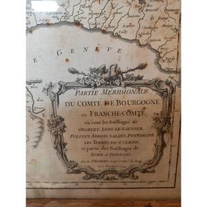
"Large Map Of Franche Comté By Sieur Robert Dated 1749 "
Large map dated 1749 drawn up by Mr. Robert, ordinary geographer of the King, representing in two sheets in folio assembled in a frame Franche-Comté and its various bailiwicks. Interesting topographical and administrative document of the old regime. It is presented under glass, as is (stains, water stains) in an oak stick. .
Price: 180 €
Period: 18th century
Style: Louis 15th - Transition
Condition: En l'etat

Material: Paper
Width: 75 cm ( cadre compris)
Height: 101 cm (cadre compris)

Reference: 1293067
Contact Dealer
line

"Pierquin Philippe" See more objects from this dealer

line

"Old Maps, Louis 15th - Transition"

More objects on Proantic.com
Subscribe to newsletter
line
facebook
pinterest
instagram
Pierquin Philippe
Tableaux anciens, objets de charme
Large Map Of Franche Comté By Sieur Robert Dated 1749
1293067-main-65e45163c7917.jpg
0033609687180


*We will send you a confirmation email from info@proantic.com Please check your messages, including the spam folder.

Thank you! Your submission has been received!

Oops! Something went wrong while submitting the form