Large Map Of Franche-comté Drawn By Jaillot Dated 1695 flag

Large Map Of Franche-comté Drawn By Jaillot Dated 1695
Large Map Of Franche-comté Drawn By Jaillot Dated 1695-photo-2
Large Map Of Franche-comté Drawn By Jaillot Dated 1695-photo-3
Large Map Of Franche-comté Drawn By Jaillot Dated 1695-photo-4
Large Map Of Franche-comté Drawn By Jaillot Dated 1695-photo-1
Large Map Of Franche-comté Drawn By Jaillot Dated 1695-photo-2
Large Map Of Franche-comté Drawn By Jaillot Dated 1695-photo-3

Object description :

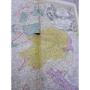
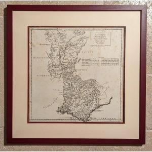
"Large Map Of Franche-comté Drawn By Jaillot Dated 1695"
Large map of Franche-Comté drawn up in 1695 by Jaillot Géographe du Roi, and dedicated to the Dauphin. Interesting topographical and administrative document showing the monarchy's desire to methodically map the kingdom. The map consists of two folio sheets, assembled in an oak frame. The glass having blown, this caused two threes in the margin, easily camouflaged with a master key..
Price: 160 €
Period: 17th century
Style: Louis 14th, Regency
Condition: En l'etat

Material: Paper
Width: 77 cm (cadre compris)
Height: 101 cm (cadre compris)

Reference: 1293095
line

"Pierquin Philippe" See more objects from this dealer

line

"Old Maps, Louis 14th, Regency"

More objects on Proantic.com
Subscribe to newsletter
line
facebook
pinterest
instagram
Pierquin Philippe
Tableaux anciens, objets de charme
Large Map Of Franche-comté Drawn By Jaillot Dated 1695
1293095-main-65e45bd1dfa6d.jpg

0033609687180


*We will send you a confirmation email from info@proantic.com Please check your messages, including the spam folder.

Thank you! Your submission has been received!

Oops! Something went wrong while submitting the form