


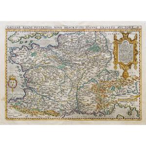


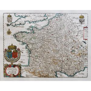
"Old Geographical Map Of France – Gallia"
Epreuve originale réalisée en 1595. Abraham Ortelius cartographe.Beaux coloris anciens.
Texte explicatif en latin au verso.
Large renfort au dos du pli central.
1 rousseur dans la marge latérale gauche au niveau de la côte espagnole.
Bon état.
Format feuille : 56 x 44,5 cm
Format gravure : 50 x 35 cm
Original antique map of 1595.
Carte particulièrement décorative réalisée par Ioanne Ioliveto en 1550 et éditée par Ortelius à la fin 16ème siècle.
Vous pouvez consulter l’ensemble des cartes et gravures disponibles sur votre région en cliquant sur le lien de notre site internet spécialisé en archives anciennes géographiques :
https://cartes-livres-anciens.com/categorie-produit/cartes-geographiques-anciennes-original-antique-maps/france/france-generale/
Règlement sécurisé par carte bancaire sur notre site internet en cliquant sur le lien :
https://cartes-livres-anciens.com/produit/cartes-geographiques-anciennes-original-antique-maps/france/france-generale/carte-geographique-ancienne-de-la-france-gallia/
Toutes nos cartes et gravures sont accompagnées d’un certificat d’authenticité.
Original proof made in 1595. Abraham Ortelius cartographer. Beautiful old colors. Explanatory text in Latin on the back. Large reinforcement on the back of the central fold. 1 foxing in the left lateral margin at the level of the Spanish coast. Good condition. Sheet format: 56 x 44.5 cm Engraving format: 50 x 35 cm Original antique map of 1595. Particularly decorative map produced by Ioanne Ioliveto in 1550 and published by Ortelius at the end of the 16th century. You can consult all the maps and engravings available in your region by clicking on the link to our website specializing in ancient geographical archives: https://cartes-livres-anciens.com/categorie-produit/cartes-gegraphiques-Ancienes -original-antique-maps/france/france-generale/ Secure payment by credit card on our website by clicking on the link: https://cartes-livres-anciens.com/produit/cartes-gegraphiques-Ancienes-original- antique-maps/france/france-generale/carte-gegraphique-Anciene-de-la-france-gallia/ All our maps and engravings are accompanied by a certificate of authenticity.


 Le Magazine de PROANTIC
 TRÉSORS Magazine
 Rivista Artiquariato