Map Of Asia, 1st Part 18th C Old Print flag

Map Of Asia, 1st Part 18th C Old Print
Map Of Asia, 1st Part 18th C Old Print-photo-2
Map Of Asia, 1st Part 18th C Old Print-photo-3
Map Of Asia, 1st Part 18th C Old Print-photo-4
Map Of Asia, 1st Part 18th C Old Print-photo-1

Object description :

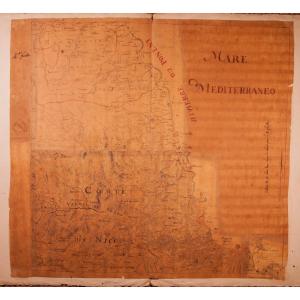
"Map Of Asia, 1st Part 18th C Old Print"
Map of Asia, 1st part
First part of the map of Asia containing Turkey, Arabia, Persia, India below the Ganges and Tartary which borders Persia and India.
Published under the auspices of Monsignor the Duke of Orléans, first Prince of the blood, by Sieur d'Anville 1751 In Paris at the author's house at the Galeries du Louvre
1751
Engraved by Guillaume de La Haye
Plate : 39.6 x 79.9 cm
Sheet: 57.5 x 86.5 cm
XVIIIth c. map
Good condition.This work has been restored by a professional & accurate restorer. 
All our old prints are offered in good condition. When necessary, they have been restored by a professional restorer.
Price: 480 €
credit
Period: 18th century
Style: Louis 15th - Transition
Condition: Good condition

Material: Paper
Width: 86,5 cm
Height: 57,5 cm

Reference: 1351114
line

"FineArtsFrance" See more objects from this dealer

line

"Old Maps, Louis 15th - Transition"

More objects on Proantic.com
Subscribe to newsletter
line
facebook
pinterest
instagram
FineArtsFrance
19th & 20th c. paintings, engravings, Fine Art dealer & expert Cnes & Cedea
Map Of Asia, 1st Part 18th C Old Print
1351114-main-6661c6401d91b.jpg

+33 143 25 34 83

+33 686324613 +33 607067552


*We will send you a confirmation email from info@proantic.com Please check your messages, including the spam folder.

Thank you! Your submission has been received!

Oops! Something went wrong while submitting the form