


"Rare Book, 1769 Geographical And Historical Description Of The Island Of Corsica Bellin Jacques"
BELLIN, Jacques-Nicolas. Geographical and Historical Description of the Isle of Corsica, to Accompany the Maps & Plans of this Isle. Paris: Imprimerie de Didot, 1769Small quarto (255 x 198 mm). Engraved index on double page, general map of Corsica and 38 engraved maps including 2 folding.
Do not hesitate to ask for more photos.
FIRST EDITION of this very beautiful atlas. It is rare to find it complete with the text volume, which includes information on Corsican history, customs, language, costumes, etc. The publication of this atlas also had political aims: the Treaty of Versailles by which Genoa ceded Corsica to France had been signed a year earlier, in May 1768. However, a military expedition was necessary in May 1769 for the King of France to definitively take control of the island.
A table of maps and 38 engraved maps: one general unnumbered at the beginning, 35 numbered from I to XXXV, one VI bis, two XXX following each other (the second being a very large "Map of the Province of Corte"), 32 double (including the second large folded dedicated to the "Province of Calvi") and six single.
Original plate 6 bis is missing and replaced by a photocopy.
Original plate 27 is missing and replaced by a photocopy.
With ex-libris.
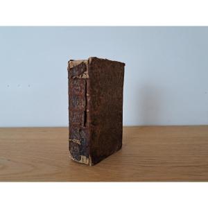
Restoration in 2004, new binding with 5 raised bands, fillets on bands. Michel Moura, bookbinder and gilder in Lyon. The invoice will be provided with the book. Presence of foxing in places, impressions of the signature of time on some pages presenting slight reliefs.
A very beautiful book
Cover: 26.3 x 20.2 cm
Weight: 1.32 Kg
Safe and secure shipping :
- Europe : 38 €
- International : 48 €
We are fluent in English and have been shipping a wide variety of items internationally for many years. Please feel free to contact us with any questions you may have. Excellent customer service, we accept returns up to 14 days, 100% positive customer reviews.
Visit our store to check all our amazing products


 Le Magazine de PROANTIC
 TRÉSORS Magazine
 Rivista Artiquariato