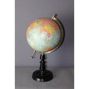
Political Globe Paul Räths Leipzig Designed By Arthur Krause is a political globe 21 centimetres in diameter, made by the firm Paul Räths, Nachf. KG, Leipzig (Leipzig), GDR (East Germany) and designed by Arthur Krause. It is in German and dates from the 1950s. It shows the political division of the world, with the borders of the various countries and the names of nations. It is an important cartographic tool that provides information on global political geography and is used for educational and research purposes.
The map is printed on twelve segments, applied to a cardboard sphere, the globe rotates on a central axis and is supported by a turned wooden pedestal. Although Räths' globes are not hard to find, the small size, the excellent condition, and the base in excellent condition that holds the globe, makes this globe an excellent piece of furniture, which is also interesting from a historical geographical, collectors' and antiquarian point of view.
The condition is very good, there is only a small peeling of about two millimetres at Mongolia.
The cartography is detailed, and the surface is all legible; the main shipping routes, railway lines (in red) and the dotted border between East and West Germany are present. Colonies and protectorates are indicated in the colour of the mother state.
The inscription above the Equator and west of Central America reads: Räths / Politischer Erdglobus / Herausgeber: Prof. Dr. Arthur Krause / Durchmesser 21 cm / Maßstab 1:60000000 / Verlag:Paul Räths, Nachf. KG, Leipzig / Verlag Lizenz Nr. K6 / Duck: VEB Hermann Haack, Gotha / Mdl der DDR Nr. 2867 Druckerei Lizenz Nr. K134


 Le Magazine de PROANTIC
 TRÉSORS Magazine
 Rivista Artiquariato