Old Map "moluccae Insulae" By Blaeu, The Spice Islands (moluccas Islands), 17th Century flag

Old Map "moluccae Insulae" By Blaeu, The Spice Islands (moluccas Islands), 17th Century
Old Map "moluccae Insulae" By Blaeu, The Spice Islands (moluccas Islands), 17th Century -photo-2
Old Map "moluccae Insulae" By Blaeu, The Spice Islands (moluccas Islands), 17th Century -photo-3

1473739-main-678a35a577f67.jpg 1473739-678a35dabf351.jpg 1473739-678a35daeb9d0.jpg

Object description :

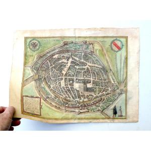
"Old Map "moluccae Insulae" By Blaeu, The Spice Islands (moluccas Islands), 17th Century "
Map "MOLUCCAE INSULAE" By Willem Janseoon BLAEU, describing the Moluccas Islands. Circa 1640 Total dimensions of the plate: 52.5 x 63 cm Dimensions of the map: 37 x 48.5 cm Comes from an atlas. Note that the plate has stains
Price: 280 €
Period: 17th century
Style: Renaissance, Louis 13th
Condition: Condition of use

Length: 63 cm
Height: 52,5 cm

Reference: 1473739
line

"Lionel FINCK" See more objects from this dealer

line

"Old Maps, Renaissance, Louis 13th"

More objects on Proantic.com
Subscribe to newsletter
line
facebook
pinterest
instagram

Lionel FINCK
arms and armor medals militaria, paintings
Old Map "moluccae Insulae" By Blaeu, The Spice Islands (moluccas Islands), 17th Century
1473739-main-678a35a577f67.jpg

06 11 94 59 47


*We will send you a confirmation email from info@proantic.com Please check your messages, including the spam folder.

Thank you! Your submission has been received!

Oops! Something went wrong while submitting the form