


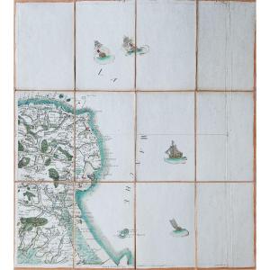
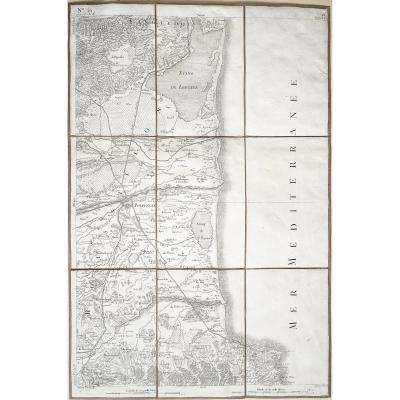
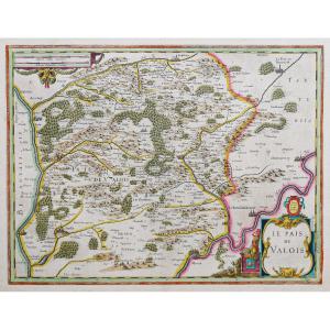
"Old Nautical Chart Of Normandy"
Epreuve originale réalisée vers 1700. Van Keulen auteur.Limites colorées de l’époque.
Rousseurs éparses.
Bon état.
Format feuille : 61,5 x 53,5 cm.
Format gravure : 60 x 52 cm.
Original antique map around 1700.
Nouvelle carte marine illustrant une partie des côtes maritimes de Normandie contenant les côtes de Cotentin et Bessin, en tirant depuis Bérée jusqu’à Cherbourg.
Boussole indiquant le nord, échelle des lieux et cartouche de titre décoratif.
Vous pouvez consulter l’ensemble des cartes, livres et gravures disponibles sur votre région en cliquant sur le lien de notre site internet spécialisé en archives anciennes géographiques :
https://cartes-livres-anciens.com/categorie-produit/cartes-geographiques-anciennes-original-antique-maps/france/normandie/
Règlement sécurisé par carte bancaire sur notre site internet en cliquant sur le lien ci-dessous :
https://cartes-livres-anciens.com/produit/cartes-geographiques-anciennes-original-antique-maps/france/normandie/carte-marine-ancienne-de-la-normandie-2/
Toutes nos cartes et gravures sont accompagnées d’un certificat d’authenticité.
Les Van Keulen étaient une famille de cartographes et d’éditeurs. La maison In de Gekroonde Lootsman (Dans le pilote couronné) fut fondée en 1678 par Johannes van Keulen (1654-1715). Van Keulen enregistra à l’origine son entreprise comme vendeur de livres et d’instruments (notamment de mâts de navigation). En 1680, il obtint cependant un privilège des États de Hollande et de Frise occidentale pour la publication de guides de pilotage et d’atlas maritimes.
Cette année-là, van Keulen publia son Zee-Atlas (Atlas maritime), qui lui assura une renommée sur le marché concurrentiel de l’édition maritime. En 1681, il publia le premier volume du Nieuwe Lichtende Zee-Fakkel (Nouveau flambeau maritime brillant). Ce serait le premier d’une série de cinq volumes publiés à l’origine entre 1680 et 1684. Un sixième volume fut ajouté en 1753. Le Zee-Fakel valut à van Keulen une renommée durable. L’atlas comprenait des cartes compilées par Claes Jansz Vooght et des illustrations de Jan Luyken. Il connut un immense succès et fut réimprimé jusqu’en 1783. Il existait des traductions en français, en anglais, en espagnol et en italien.
La fin du 17e siècle fut une période propice pour se lancer dans le commerce des cartes maritimes. Les dirigeants précédents de l’industrie avaient fermé boutique, étaient décédés ou avaient pris leur retraite, laissant la place à un nouveau concurrent. Van Keulen procéda alors au rachat des actions et des privilèges de plusieurs maisons d’édition maritimes, la plus notable étant celle de Hendrik Doncker, acquise en 1693.
Le fils de Johannes, Gérard (1678-1726), reprit l’affaire à la mort de son père. Gérard était un graveur et un mathématicien talentueux. Ses talents furent remarqués, puisqu’en 1706 il fut nommé hydrographe de la Compagnie néerlandaise des Indes orientales (VOC).
Le fils de Gérard, Johannes II (1704-1770), prit à son tour la direction de la boutique. Il était également lié à la VOC et son rôle de cartographe lui permit de considérer ses cartes comme des documents gouvernementaux quasi officiels. C’est grâce à l’accès aux connaissances géographiques jusque-là clandestines de la VOC que Johannes le Jeune put ajouter un sixième volume au Zee-Fakkel , qui couvrait les Indes orientales. Johannes continua également à vendre des instruments, notamment le quadrant de Hadley récemment inventé en 1744.
Original proof made around 1700. Van Keulen author. Coloured boundaries of the time. Scattered foxing. Good condition. Sheet size: 61.5 x 53.5 cm. Engraving size: 60 x 52 cm. Original antique map around 1700. New nautical chart illustrating part of the maritime coasts of Normandy containing the coasts of Cotentin and Bessin, drawing from Bérée to Cherbourg. Compass indicating the north, scale of places and decorative title cartouche. You can view all the maps, books and engravings available in your region by clicking on the link to our website specializing in old geographical archives: https://cartes-livres-anciens.com/categorie-produit/cartes-geographiques-anciennes-original-antique-maps/france/normandie/ Secure payment by credit card on our website by clicking on the link below: https://cartes-livres-anciens.com/produit/cartes-geographiques-anciennes-original-antique-maps/france/normandie/carte-marine-ancienne-de-la-normandie-2/ All our maps and engravings are accompanied by a certificate of authenticity. The Van Keulen family were cartographers and publishers. The house In de Gekroonde Lootsman (In the crowned pilot) was founded in 1678 by Johannes van Keulen (1654-1715). Van Keulen originally registered his business as a seller of books and instruments (including navigation masts). In 1680, however, he obtained a privilege from the states of Holland and West Friesland for the publication of pilotage guides and maritime atlases. That year, van Keulen published his Zee-Atlas (Maritime Atlas), which brought him fame in the competitive maritime publishing market. In 1681, he published the first volume of the Nieuwe Lichtende Zee-Fakkel (New Bright Maritime Torch). This would be the first in a series of five volumes originally published between 1680 and 1684. A sixth volume was added in 1753. The Zee-Fakel brought van Keulen lasting fame. The atlas included maps compiled by Claes Jansz Vooght and illustrations by Jan Luyken. It was a huge success and was reprinted until 1783. There were translations in French, English, Spanish and Italian. The late 17th century was a good time to start trading in maritime charts. The previous leaders of the industry had closed shop, died or retired, leaving room for a new competitor. Van Keulen then bought out the shares and privileges of several maritime publishing houses, the most notable being that of Hendrik Doncker, acquired in 1693. Johannes' son Gerard (1678-1726) took over the business after his father's death. Gerard was a talented engraver and mathematician. His talents were noticed, since in 1706 he was appointed hydrographer of the Dutch East India Company (VOC). Gerard's son Johannes II (1704-1770) in turn took over the management of the shop. He was also connected to the VOC, and his role as a cartographer allowed him to regard his maps as quasi-official government documents. It was through access to the VOC's previously clandestine geographical knowledge that Johannes the Younger was able to add a sixth volume to the Zee-Fakkel , which covered the East Indies. Johannes also continued to sell instruments, including the newly invented Hadley Quadrant in 1744.


 Le Magazine de PROANTIC
 TRÉSORS Magazine
 Rivista Artiquariato