


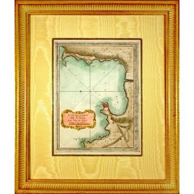
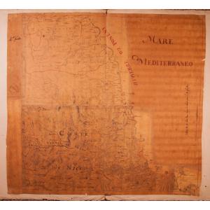
"Engraving - Marine Chart - "part Of Flanders, Picardy And Boulogne - No. 1" - Ep. Mid"
RARE Original proof made in 1757 by Georges Louis Le ROUGE cartographer. Nautical details: The half-fleur-de-lys indicating the north, the sandbanks, the currents and the sea depths are clearly indicated, essential elements for sailors of the time. A compass rose is also present, facilitating orientation at sea. The border of the map is richly decorated with colorful patterns, with elements evoking nautical instruments, weapons and foliage. These ornaments add an artistic touch while reflecting the symbolic and practical importance of the map. Particularly detailed survey of the coasts, on a scale of 2 half-leagues, made by Georges Le Rouge, engineer of fortifications and geographer of King Louis XV. He was also a military engineer in the service of the Count of Clermont, as well as an engraver, publisher and print dealer. Beautiful hand watercolor colors. Dimension(s): Frame: Height. 43 cm – Length 52.2 cm - Width Baguette: 2.5 cm, Condition: PERFECT CONDITION, Period: MID-18th century (1757), Frame: CURRENT - Brown beveled fillet - Marie-Louise in ecru wild silk - Brown wooden baguette, with an aged gold patina. 18th century nautical charts are rare for several historical, technical and practical reasons. At that time, they were made by hand in small quantities, intended mainly for military or commercial navigation, without mass production. Used intensively at sea, they were subjected to difficult conditions (humidity, salt, handling), often leading to their deterioration or loss, which explains the rarity of copies in good condition. In addition, these maps were considered strategic documents in a context of maritime rivalries between powers such as France, England and Spain. Their distribution was strictly controlled to prevent them from falling into the wrong hands. They were also regularly updated to correct errors or incorporate new discoveries, which quickly made old maps obsolete and often destroyed or replaced. Finally, many nautical charts were kept in private collections or archives, reducing their availability on the market. These factors make them rare and valuable objects, both historical tools, works of art sought after by amateurs, and magnificent decorative documents. PAYMENT and TRANSPORT PAYMENTS ACCEPTED via PAYPAL / TRANSFER / CB online or by CHECK. PACKAGES WILL BE POSTED WITHIN 4 DAYS. GROUPED SHIPPING POSSIBLE IN CASE OF PURCHASE OF MULTIPLE ITEMS. 


 Le Magazine de PROANTIC
 TRÉSORS Magazine
 Rivista Artiquariato