


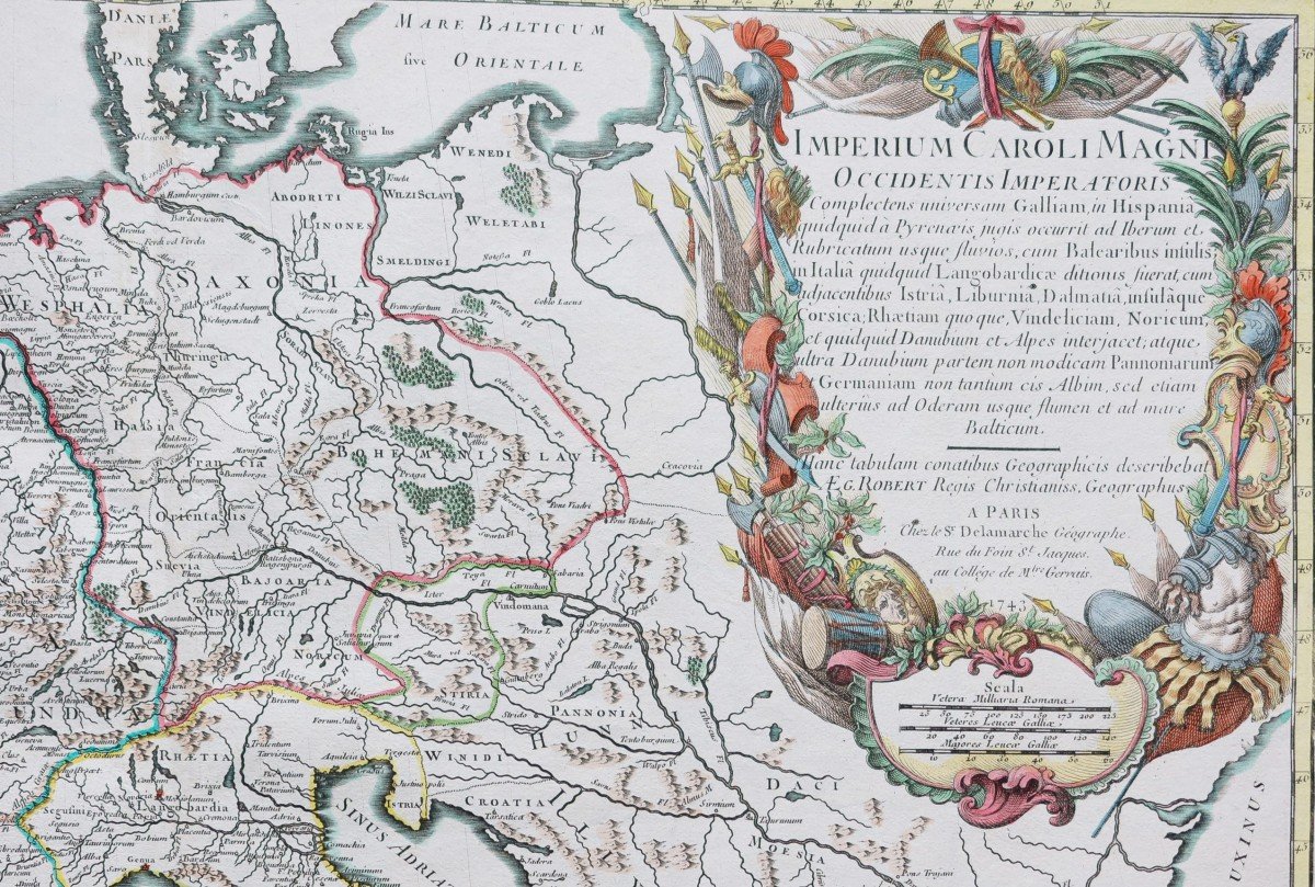


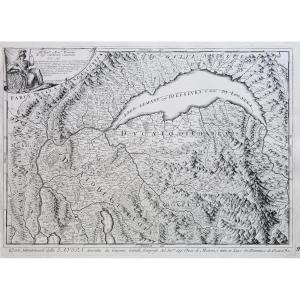
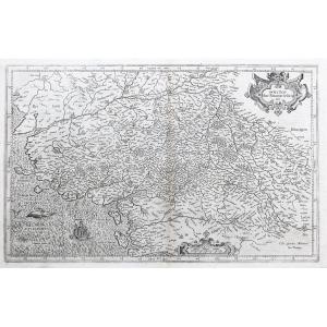
"Old Map Of Europe – Empire Of Charlemagne"
Imperium Caroli magni, occidentis imperatoris complectens universam Galliam, in Hispania quidquid à Pyrenaeis jugis occurrit ad Iberum et Rubricatum usque fluvios, cum Balearibus insulis, in Italiã quidquid Langobardicae ditionis fuerat cum adjacentibus…Epreuve originale réalisée en 1743. Robert de Vaugondy géographe.
Beaux coloris aquarelle.
Rousseurs claires dans les grandes marges latérales loin du trait d’encadrement.
Bon état.
Format feuille : 76,5 x 56 cm.
Format gravure : 65 x 48 cm.
Original antique map of 1743.
Grande carte de l’Empire carolingien au 9ème siècle, avec les limites colorées de l’époque, rose des vents, large cartouche de titre illustré d’attributs militaires, échelle des lieux.
Vous pouvez consulter l’ensemble des cartes et gravures disponibles sur votre région en cliquant sur le lien de notre site internet spécialisé en archives anciennes géographiques :
https://cartes-livres-anciens.com/categorie-produit/cartes-geographiques-anciennes-original-antique-maps/monde-cartes-marines/continents/
Règlement sécurisé par carte bancaire sur notre site internet en cliquant sur le lien :
https://cartes-livres-anciens.com/produit/cartes-geographiques-anciennes-original-antique-maps/monde-cartes-marines/continents/carte-geographique-ancienne-empire-de-charlemagne/
Toutes nos cartes et gravures sont accompagnées d’un certificat d’authenticité.
Gilles Robert de Vaugondy, dit Robert de Vaugondy, né en 1688 et mort en 1766, est un géographe et cartographe français.
Petit-fils de Nicolas Sanson, il est nommé géographe du Roi. Il est le père du géographe et cartographe Didier Robert de Vaugondy (1723-1786), avec lequel il compose une collection de carte sur le Monde, parue en 1757.
Imperium Caroli magni, occidentis imperatoris complectens universam Galliam, in Hispania quidquid à Pyrenaeis jugis occurrit ad Iberum et Rubricatum usque fluvios, cum Balearibus insulis, in Italiã quidquid Langobardicae ditionis fuerat cum adjacentibus… Original proof produced in 1743. Robert de Vaugondy geographer. Beautiful watercolor colors. Light foxing in the large lateral margins far from the framing line. Good condition. Sheet size: 76.5 x 56 cm. Engraving format: 65 x 48 cm. Original antique map of 1743. Large map of the Carolingian Empire in the 9th century, with the colored limits of the time, compass rose, large title cartridge illustrated with military attributes, scale of the places. You can view all the maps and engravings available in your region by clicking on the link to our website specializing in old geographical archives: https://cartes-livres-anciens.com/categorie-produit/cartes-geographiques-anciennes-original-antique-maps/monde-cartes-marines/continents/ Secure payment by credit card on our website by clicking on the link: https://cartes-livres-anciens.com/produit/cartes-geographiques-anciennes-original-antique-maps/monde-cartes-marines/continents/carte-geographique-ancienne-empire-de-charlemagne/ All our maps and engravings are accompanied by a certificate of authenticity. Gilles Robert de Vaugondy, known as Robert de Vaugondy, born in 1688 and died in 1766, is a French geographer and cartographer. Grandson of Nicolas Sanson, he was appointed geographer to the King. He is the father of the geographer and cartographer Didier Robert de Vaugondy (1723-1786), with whom he composed a collection of maps of the World, published in 1757.


 Le Magazine de PROANTIC
 TRÉSORS Magazine
 Rivista Artiquariato