


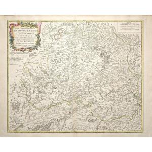
"Old Map – Diocese Of Uzès – Cévennes"
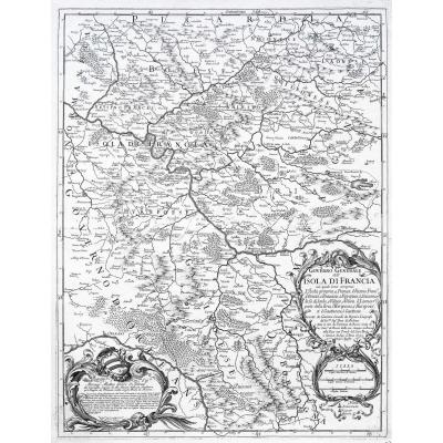
Carte du Diocèse d’Uzès, dressée sur les lieux par le Sr Gautier, ingénieur, architecte et inspecteurs des Ponts et Chaussées.Grande épreuve entoilée d’époque, réalisée vers 1720. Nolin géographe.
Coloris aquarelle.
Cette carte entoilée s’encadre facilement après pressage chez un encadreur.
Très bon état.
Format feuille : 65,5 x 51,5 cm.
Format gravure : 64 x 50,5 cm.
Original antique map around 1720.
Grande carte peu courante, illustrant l’ancienne province du Languedoc.
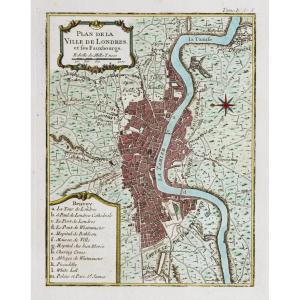
Encarts avec plans de la ville d’Uzès, Avignon, Pont St Esprit et renvois situant les principaux édifices et lieux.
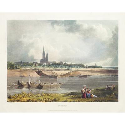
Illustration du Pont St Esprit et façade du Pont d’Arles.
Carte éditée début 18e siècle chez la veuve du Sieur Nolin géographe ordinaire du Roy.
Vous pouvez consulter l’ensemble des cartes et gravures disponibles sur votre région en cliquant sur le lien de notre site internet spécialisé en archives anciennes géographiques :
https://cartes-livres-anciens.com/categorie-produit/cartes-geographiques-anciennes-original-antique-maps/france/languedoc-roussillon/
Règlement sécurisé par carte bancaire sur notre site internet en cliquant sur le lien :
https://cartes-livres-anciens.com/produit/cartes-geographiques-anciennes-original-antique-maps/france/languedoc-roussillon/carte-ancienne-diocese-duzes/
Toutes nos cartes et gravures sont accompagnées d’un certificat d’authenticité.
Nolin Jean-Baptiste, Fils d’un graveur de la rue Saint-Jacques, Jean-Baptiste Nolin (1657 -1708) devint géographe du duc d’Orléans puis géographe du roi. Les quatre collections de cartes de Nolin recensés sont assez rares. Trois d’entre elles se rapportent aux événements militaires des Pays Bas, d’Italie et d’Allemagne. Le quatrième est une collection sur le monde, baptisée le Théâtre du monde. La succession de Nolin fut assurée par son fils, prénommé également Jean-Baptiste. Ce dernier publia en 1746 une réédition du Théâtre du monde.
Map of the Diocese of Uzès, drawn up on site by Mr Gautier, engineer, architect and inspector of Bridges and Roads. Large canvas-backed proof from the period, produced around 1720. Nolin geographer. Watercolor colors. This canvas-backed map can be easily framed after pressing at a framer. Very good condition. Sheet size: 65.5 x 51.5 cm. Engraving size: 64 x 50.5 cm. Original antique map around 1720. Large, unusual map, illustrating the former province of Languedoc. Inserts with plans of the town of Uzès, Avignon, Pont St Esprit and references locating the main buildings and places. Illustration of the Pont St Esprit and the facade of the Pont d'Arles. Map published in the early 18th century by the widow of Mr Nolin, ordinary geographer of the King. You can view all the maps and engravings available in your region by clicking on the link to our website specializing in old geographical archives: https://cartes-livres-anciens.com/categorie-produit/cartes-geographiques-anciennes-original-antique-maps/france/languedoc-roussillon/ Secure payment by credit card on our website by clicking on the link: https://cartes-livres-anciens.com/produit/cartes-geographiques-anciennes-original-antique-maps/france/languedoc-roussillon/carte-ancienne-diocese-duzes/ All our maps and engravings are accompanied by a certificate of authenticity. Nolin Jean-Baptiste, Son of an engraver from rue Saint-Jacques, Jean-Baptiste Nolin (1657 -1708) became geographer to the Duke of Orleans and then geographer to the king. The four collections of Nolin maps listed are quite rare. Three of them relate to military events in the Netherlands, Italy and Germany. The fourth is a collection on the world, called the Théâtre du monde. Nolin's succession was ensured by his son, also named Jean-Baptiste. The latter published a reissue of the Théâtre du monde in 1746.


 Le Magazine de PROANTIC
 TRÉSORS Magazine
 Rivista Artiquariato