


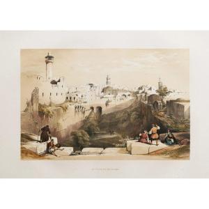
"Old Geographic Map Of Palestine – Holy Land"
Epreuve originale réalisée en 1614.Mouillures dans les angles inférieurs et supérieurs de la gravure, s’arrêtant au raz du cuivre.
Bon état.
Format feuille : 43,5 x 36,5 cm.
Format gravure : 36 x 26 cm.
Original antique map of 1614.
Rare carte de la Palestine gravée sur cuivre, illustrantles deux côtés du Jourdain, avec divisions des tribus, lieux de sépulture. Annotations sur les batailles et autres lieux d’importance biblique.
Les villes d’Adama, Seboim, Sodome et Gomorrhe sont représentées en train de brûler dans la mer Morte. La zone située au-dessus de la Palestine est désignée comme le désert d’Arabie et l’Arabie la pierre. Le nord est orienté vers la gauche indiqué par une rose des vents.
Vous pouvez consulter l’ensemble des cartes et gravures disponibles sur votre région en cliquant sur le lien de notre site internet spécialisé en archives anciennes géographiques :
https://cartes-livres-anciens.com/categorie-produit/cartes-geographiques-anciennes-original-antique-maps/moyen-orient/israel-palestine-jordanie/
Règlement sécurisé par carte bancaire sur notre site internet en cliquant sur le lien :
https://cartes-livres-anciens.com/produit/cartes-geographiques-anciennes-original-antique-maps/moyen-orient/israel-palestine-jordanie/carte-geographique-ancienne-de-la-palestine-terre-sainte/
Toutes nos cartes et gravures sont accompagnées d’un certificat d’authenticité.
Original proof made in 1614. Water stains in the lower and upper corners of the engraving, stopping at the copper. Good condition. Sheet size: 43.5 x 36.5 cm. Engraving size: 36 x 26 cm. Original antique map of 1614. Rare copper-engraved map of Palestine, illustrating both sides of the Jordan, with divisions of tribes, burial sites. Annotations on battles and other places of biblical importance. The cities of Adama, Seboim, Sodom and Gomorrah are shown burning in the Dead Sea. The area above Palestine is designated as the Arabian Desert and Arabia the Stone. North is oriented to the left indicated by a compass rose. You can view all the maps and engravings available in your region by clicking on the link to our website specializing in old geographical archives: https://cartes-livres-anciens.com/categorie-produit/cartes-geographiques-anciennes-original-antique-maps/moyen-orient/israel-palestine-jordanie/ Secure payment by credit card on our website by clicking on the link: https://cartes-livres-anciens.com/produit/cartes-geographiques-anciennes-original-antique-maps/moyen-orient/israel-palestine-jordanie/carte-geographique-ancienne-de-la-palestine-terre-sainte/ All our maps and engravings are accompanied by a certificate of authenticity.


 Le Magazine de PROANTIC
 TRÉSORS Magazine
 Rivista Artiquariato