


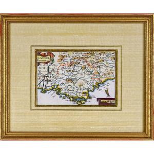
"Map Of Languedoc. Louis XIV Era"
MAP AND GENERAL DESCRIPTION OF LANGUEDOC Drawn up by Jean Cavalier d'Agde, geographer to the king in 1621. In 1627, while he was 1st Consul of Agde, he married Dame d'Estienne at Notre-Dame du Grau. In 1634, he drew up an estimate for the port that Richelieu wanted to build at Cap d'Agde. During his long career, he was notably controller general of fortifications of Languedoc, inspector of works at the port of Cap d'Agde (from 1648 to 1653) and in charge of inspecting the Languedoc canal (c. 1664-1665). In 1653, he drew up the estimate for the new hospital wanted by Bishop François Fouquet. He drew up numerous maps of the province of Languedoc. Jean Boisseau, engraver of this map, was born before 1631 and died after April 1657, was a French master illuminator. Note: sold as is, wear. Paper fixed on a fine canvas. 


 Le Magazine de PROANTIC
 TRÉSORS Magazine
 Rivista Artiquariato