Dauphiné. 17th Century Map flag

Dauphiné. 17th Century Map
Dauphiné. 17th Century Map -photo-2

1504624-main-67cc699c03491.jpg 1504624-67cc69b12e3ed.jpg

Object description :

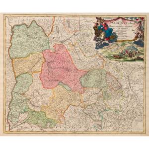
"Dauphiné. 17th Century Map "
"Tabula Delphinatus vulgo, The General Government of DAUPHINÉ… Jo Baptista Homanno…" Edited by Johann HOMANN (1663-1724) German Geographer and Cartographer.
Copper engraving.
Printed in Nuremberg. Early 18th century. Sheet
54 x 62 cm
Price: 450 €
Artist: Johann Homann
Period: 18th century
Style: Other Style
Condition: Perfect condition

Material: Paper
Width: 62 cm
Height: 54 cm

Reference: 1504624
line

"Galerie Vaujany" See more objects from this dealer

line

"Old Maps, Other Style"

More objects on Proantic.com
Subscribe to newsletter
line
facebook
pinterest
instagram

Galerie Vaujany
Art ancien
Dauphiné. 17th Century Map
1504624-main-67cc699c03491.jpg

04 76 43 78 57


*We will send you a confirmation email from info@proantic.com Please check your messages, including the spam folder.

Thank you! Your submission has been received!

Oops! Something went wrong while submitting the form