


"Engraving - Government Of Provins (seine-et-marne - 77) - Ep. 17th"
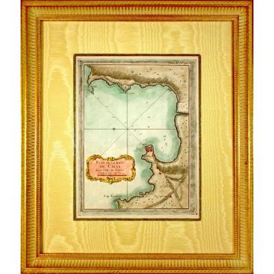
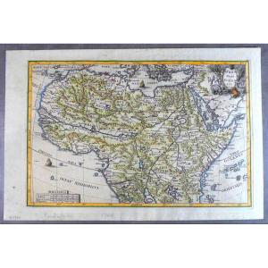
Engraving GOVERNMENT OF PROUINS (PROVINS - 77) RARE Burin engraving on steel, by Christophe TASSIN, born in the early 1600s and died in 1660, in France, also known as Nicolas Tassin, Christophe Nicolas Tassin or Christophe Le Tassin, French cartographer, known for his atlas of France, Spain, Germany and Switzerland. Most of his work was published in Paris from 1633 to 1635. This engraving depicts the Gouvernement de Provins, an administrative and military subdivision under the Ancien Régime. It shows towns and villages represented by small icons of buildings, streams and rivers, forests and woods stylized in green, indicating the main wooded areas of the territory, and roads and communication routes connecting the main towns, although not very detailed. Nicolas Tassin's maps were primarily intended for military and administrative uses, commissioned by the state to map the governments and provinces of the Kingdom of France. His works are distinguished by their clarity, precision and refined aesthetics, typical of the early 17th century. This map of the Gouvernement de Provins is therefore part of a larger series of representations of French administrative divisions under Louis XIII, providing an overview of the infrastructure and defenses of the time. Dimensions: Length 28.6 cm – Height 23.6 cm - Width 23.6 cm of the baguette 1 cm,Condition(s): PERFECT CONDITION,Era: 1st HALF of the 17th century,Frame: CURRENT - Aged gold bevel - Marie-Louise in ecru blue wild silk - Wooden baguette, aged water gilding. 


 Le Magazine de PROANTIC
 TRÉSORS Magazine
 Rivista Artiquariato