


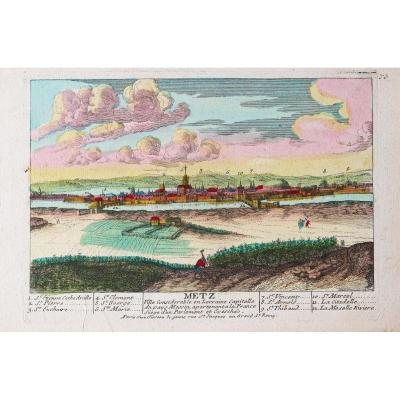
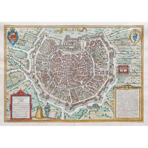
"Old Engraving Of Strasbourg"
Epreuve originale réalisée vers 1650. Merian éditeur.Très beau coloris aquarelle.
Fines rousseurs claires éparses.
Traces de plis anciens dont un pincement de papier dans l’angle supérieur droit.
Etat correct.
Format feuille : 40,5 x 33,5 cm.
Format gravure : 38,5 x 24 cm.
Original antique engraving around 1650.
Vous pouvez consulter l’ensemble des cartes, livres et gravures disponibles sur votre région en cliquant sur le lien de notre site internet spécialisé en archives anciennes géographiques :
https://cartes-livres-anciens.com/categorie-produit/cartes-geographiques-anciennes-original-antique-maps/france/alsace-lorraine/
Règlement sécurisé par carte bancaire sur notre site internet en cliquant sur le lien ci-dessous :
https://cartes-livres-anciens.com/produit/cartes-geographiques-anciennes-original-antique-maps/france/alsace-lorraine/gravure-ancienne-de-strasbourg-2/
Toutes nos cartes et gravures sont accompagnées d’un certificat d’authenticité.
Mattheus Merian est né le 22 septembre 1593 à Bâle, fils de Walther Merian. Après ses études au lycée, il apprit le dessin, la gravure sur cuivre et la gravure à l’eau-forte à Zurich auprès du graveur sur cuivre Friedrich Meyer. De 1610 à 1615, il étudia et travailla à Strasbourg (chez Dietrich Brentel), Nancy et à Paris (chez Jacques Callot). En 1615, il réalisa à Bâle son grand plan de la ville de Bâle.
Après des séjours à Augsbourg et Stuttgart (Allemagne) ainsi qu’aux Pays Bas, Merian s’installa à Francfort-sur-le-Main et à Oppenheim (Allemagne), où il travailla pour l’éditeur et le graveur sur cuivre Johann Theodor de Bry. De Bry possédait un atelier de gravure à Oppenheim et une maison d’édition à Francfort qui préparait alors de grands ouvrages de voyages en Extrême-Orient. En 1617, il épousa la fille de son employeur, Maria Magdalena de Bry, s’installa en 1616 à Bâle, où il acquit le droit de corporation qui lui permit de devenir indépendant.
Original proof made around 1650. Merian publisher. Very beautiful watercolor coloring. Scattered light fine foxing. Traces of old folds including a paper pinch in the upper right corner. Good condition. Sheet size: 40.5 x 33.5 cm. Engraving size: 38.5 x 24 cm. Original antique engraving around 1650. You can consult all the maps, books and engravings available in your region by clicking on the link to our website specializing in old geographical archives: https://cartes-livres-anciens.com/categorie-produit/cartes-geographiques-anciennes-original-antique-maps/france/alsace-lorraine/ Secure payment by credit card on our website by clicking on the link below: https://cartes-livres-anciens.com/produit/cartes-geographiques-anciennes-original-antique-maps/france/alsace-lorraine/gravure-ancienne-de-strasbourg-2/ All our maps and engravings are accompanied by a certificate of authenticity.Mattheus Merian was born on September 22, 1593 in Basel, son of Walther Merian. After graduating from high school, he learned drawing, copperplate engraving, and etching in Zurich from the copperplate engraver Friedrich Meyer. From 1610 to 1615, he studied and worked in Strasbourg (with Dietrich Brentel), Nancy, and Paris (with Jacques Callot). In 1615, he produced his large-scale map of the city of Basel in Basel. After stays in Augsburg and Stuttgart (Germany) as well as in the Netherlands, Merian settled in Frankfurt am Main and Oppenheim (Germany), where he worked for the publisher and copperplate engraver Johann Theodor de Bry. De Bry owned an engraving workshop in Oppenheim and a publishing house in Frankfurt, which was preparing major travel books in the Far East. In 1617, he married his employer's daughter, Maria Magdalena de Bry, and in 1616 moved to Basel, where he acquired the guild rights that allowed him to become independent.


 Le Magazine de PROANTIC
 TRÉSORS Magazine
 Rivista Artiquariato