


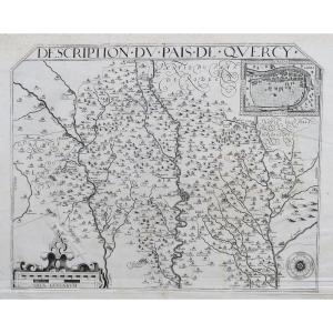
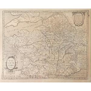
"Old Geographic Map Of Picardy"
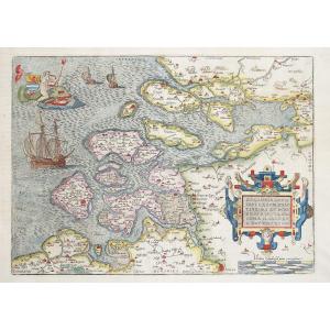
Epreuve originale réalisée en 1592. Maurice Bouguereau cartographe.1 rousseur marquée dans l’étang de Vandeuil.
Très bon état.
Format feuille : 55 x 41 cm.
Format gravure : 46 x 33,5 cm.
Original antique map of 1592.
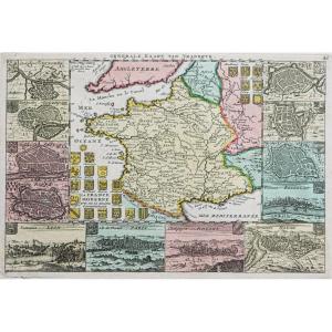
Rare carte de Bouguereau reprenant la géographie de Joanne Surhonio éditée la première fois par Abraham Ortelius en 1579.
Belle impression pour cette carte en premier tirage avec privilèges.
Vous pouvez consulter l’ensemble des cartes, livres et gravures disponibles sur votre région en cliquant sur le lien de notre site internet spécialisé en archives anciennes géographiques :
https://cartes-livres-anciens.com/categorie-produit/cartes-geographiques-anciennes-original-antique-maps/france/picardie-oise/
Règlement sécurisé par carte bancaire sur notre site internet en cliquant sur le lien ci-dessous :
https://cartes-livres-anciens.com/produit/cartes-geographiques-anciennes-original-antique-maps/france/picardie-oise/carte-geographique-ancienne-de-la-picardie-3/
Toutes nos cartes et gravures sont accompagnées d’un certificat d’authenticité.
Maurice Bouguereau (15 ? – 1596) était un imprimeur et libraire français. Le Theatre Françoys, premier atlas de France, naquit de l’association, entre 1590 et 1594, de Bouguereau et du graveur Gabriel Tavernier. Ce dernier, originaire d’Anvers et réfugié en France, apportait ses capacités techniques – encore inégalées en France -, tandis que Bouguereau endossait le risque commercial de l’entreprise et réunissait les cartes manuscrites qui devaient composer le recueil. Il fut stimulé et aidé pour cela par la présence à Tours du roi, de la Cour et du Parlement.
Bouguereau voulut même que son atlas fût le symbole de l’unité nationale et l’image d’un royaume dans lequel toutes les provinces seraient dévouées à leur souverain. Il ne put cependant pas réunir autant de cartes qu’il l’aurait souhaité, il fit ainsi copier par Tavernier huit cartes qui figuraient déjà dans le Theatrum orbis terrarum d’Abraham Ortelius et quatre tirées des Galliae tabulae geographicae de G. Mercator. 3 autres cartes avaient déjà connu une version française : La France de Postel, le Maine et la Bretagne ; et donc seulement 3 pièces étaient imprimées pour la première fois : le Blaisois, la Touraine, et le Limousin.
Les cuivres de Bouguereau, rachetés par Jean Leclerc, furent encore retirés pendant de nombreuses années, et constituent une étape très marquante de l’histoire de la cartographie française et de sa diffusion.
Original proof made in 1592. Maurice Bouguereau cartographer. 1 foxing marked in the pond of Vandeuil. Very good condition. Sheet size: 55 x 41 cm. Engraving size: 46 x 33.5 cm. Original antique map of 1592. Rare map by Bouguereau using the geography of Joanne Surhonio first published by Abraham Ortelius in 1579. Beautiful impression for this map in first edition with privileges. You can consult all the maps, books and engravings available on your region by clicking on the link of our website specialized in old geographical archives: https://cartes-livres-anciens.com/categorie-produit/cartes-geographiques-anciennes-original-antique-maps/france/picardie-oise/ Secure payment by credit card on our website by clicking on the link below: https://cartes-livres-anciens.com/produit/cartes-geographiques-anciennes-original-antique-maps/france/picardie-oise/carte-geographique-ancienne-de-la-picardie-3/ All our maps and engravings are accompanied by a certificate of authenticity.Maurice Bouguereau (15? – 1596) was a French printer and bookseller. The Theatre Françoys, the first atlas of France, was born from the association, between 1590 and 1594, of Bouguereau and the engraver Gabriel Tavernier. The latter, originally from Antwerp and a refugee in France, brought his technical skills – still unequaled in France – while Bouguereau took on the commercial risk of the enterprise and gathered the handwritten maps that would make up the collection. He was stimulated and helped in this by the presence in Tours of the king, the Court and the Parliament. Bouguereau even wanted his atlas to be the symbol of national unity and the image of a kingdom in which all the provinces would be devoted to their sovereign. However, he was not able to gather as many maps as he would have liked, so he had Tavernier copy eight maps that already appeared in the Theatrum orbis terrarum of Abraham Ortelius and four taken from the Galliae tabulae geographicae of G. Mercator. 3 other maps had already had a French version: La France de Postel, Maine and Brittany; and therefore only 3 pieces were printed for the first time: Blaisois, Touraine, and Limousin. Bouguereau's copperplates, bought by Jean Leclerc, were still withdrawn for many years, and constitute a very significant stage in the history of French cartography and its diffusion.


 Le Magazine de PROANTIC
 TRÉSORS Magazine
 Rivista Artiquariato