


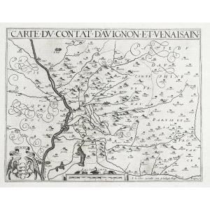
"Ancient Geographical Map Of Brittany - Mercator Cartographe - Britain Antique Map"
Original map engraved on copper around 1610.Beautiful old colors.
Explanatory text in French on the back.
very good state.
Sheet format: 48 x 36 cm
Original antique map of 1610.
You can consult all the maps and engravings available in your region by clicking on the link from our website specializing in ancient geographic archives: https: //www.cartes- livres-anciens.com
Possibility of secure payment by bank card on our website:https://cartes-livres-anciens.com/produit/cartes/france/bretagne/carte-geographique-ancienne-de-bretagne-mercator-cartographe-britain-antique-map/
The originality of Mercator is based on the projection of the Earth's surface on a cylinder tangent to the equator which has the advantage of not distorting the angles. We also speak of a tangent cylindrical representation, where the meridians are regularly spaced while the distance between parallels increases with latitude. At the end of the sixteenth century, the geography of the world was finally expressed in its true form and proportions. With the printing press, Europe becomes an information and dissemination center for increasingly reliable geographic maps. Mercator was involved in his life during the course of his life with ecclesiastical authorities who suspected him of heresy. So in 1533 he had to leave Louvain to avoid an investigation into his personal beliefs. Ten years later, he was arrested for heresy in Antwerp and imprisoned in Rupelmonde, but managed to get out of this bad step. Mercator was buried in Duisburg, where he had lived since 1552. His works are also on display there.


 Le Magazine de PROANTIC
 TRÉSORS Magazine
 Rivista Artiquariato