


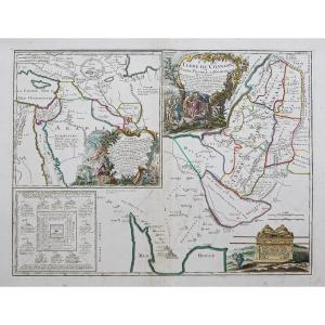


"Ancient Geographical Map The Promised Land"
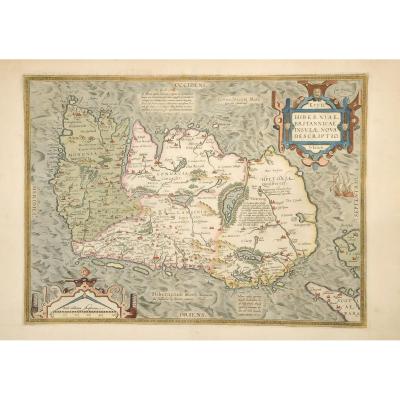
Land of Chanaan or Land Promised to Abraham and his posterity. Original proof made in 1790. Robert de Vaugondy geographer. At Delamarche. Colored boundaries of the time. Small stains in the top of the upper margin not reaching the map. Good condition. Sheet size: 69 x 56 cm. Copper format: 57 x 43 cm. Original antique map of 1790. Large decorative title cartouche of Abraham's journey and the layout of an Israelite camp around the Ark of the Covenant. You can consult all the maps and engravings available in your region by clicking on the link of our website specializing in ancient geographical archives: https://cartes-livres-anciens.com/categorie-produit/cartes-geographiques-anciennes -original-antique-maps/moyen-orient/israel-palestine-jordanie/ Secure payment by credit card on our website by clicking on the link: https://cartes-livres-anciens.com/produit/cartes-geographiques- ancient-original-antique-maps/middle-east/israel-palestine-jordan/ancient-geographical-map-the-promised-land/ All our maps and engravings are accompanied by a certificate of authenticity. 


 Le Magazine de PROANTIC
 TRÉSORS Magazine
 Rivista Artiquariato