Engraving GOVERNMENT OF PROUINS (PROVINS - 77) RARE Burin engraving on steel, by Christophe TASSIN, born in the early 1600s and died in 1660, in France, also known as Nicolas Tassin, Christophe Nicola[...]
Map of the Diocese of Castres, dedicated to Messire Augustin de Maupéou, Advisor to the King in his councils, Bishop of Castres, by his very humble and very obedient servant HUBERT JAILLOT, Geographer[...]
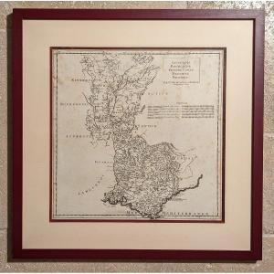
MAP AND GENERAL DESCRIPTION OF LANGUEDOC Drawn up by Jean Cavalier d'Agde, geographer to the king in 1621. In 1627, while he was 1st Consul of Agde, he married Dame d'Estienne at Notre-Dame du Grau. I[...]
Original steel engraving with a burin. Engraved by Tassin (Christophe), often mistakenly confused with Nicolas Tassin, he was in reality the King's engineer-geographer. Although his dates of birth and[...]
View of the city of Grenoble in a "cavalier plan", that is to say seen from above. The original of this representation, made by F. Hogenberg, dates from 1588. This one is a 17th century copy, which wa[...]
Page 67 of a work from the beginning of the 18th century "Genesis"
Sheet 54 X 39 cm plate 19 X 30 cm
Very good condition
Date: 1704 or 1724
"Adjoining the Historical Table of the First Age of th[...]
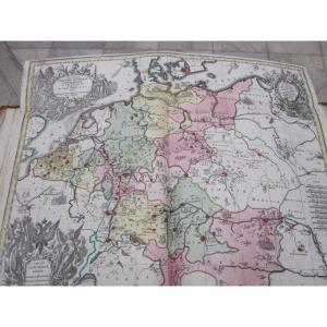
RARE MAP of the DUCHY of BURGUNDY accompanied by the COAT OF COAT "Quarterled at 1 and 4 of modern Burgundy which is Semé de France with the Border composed of silver and gules at 2 and 3 of old Burgu[...]
-Ornamental cartridge with coat of arms. - List of battalions and squadrons at the headquarters of Lille. Plan of the city of Lille, France invested by the Haut-Allies under the command of HH Prince E[...]
Very beautiful map of Nice, The city and the castle, Watercolored, Work from the 18th/19th century. In very good condition, Weight: 1300 gr. Dimensions: Height: 34 cm, Width: 44 cm. At sight: Height: [...]
Original engraving on steel with a chisel. Engraved by TASSIN (Christophe), known by mistake as Nicolas Tassin. He is in reality the King's geographical engineer. We do not know his dates of birth and[...]
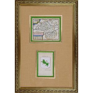
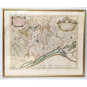
RARE MAP of ROUERGUE accompanied by the COAT OF “Leopard lion”. By Pierre DU VAL D'ABBEVILLE, geographer to His Majesty LOUIS XIV. ORIGINAL engraving with a chisel on steel. Beautiful hand watercolor [...]
Original engraving on steel with a chisel. Engraved by TASSIN (Christophe), known by mistake as Nicolas Tassin. He is in reality the King's geographical engineer. We do not know his dates of birth and[...]
État : Excellent, la feuille a été doublée, ce qui la rendu solide. Les couleurs d’époque sont fraîches.
(Pour le texte suivant, je me suis largement inspiré d’une traduction d’un texte de Curtis Wri[...]
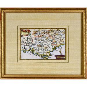
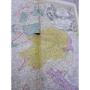
RARE MAP of NIVERNOIS accompanied by the COAT OF COAT (Banded in gold and azure, with the engrailed border of Gueules) of this same region. By Pierre DU VAL D'ABBEVILLE, geographer to His Majesty LOUI[...]
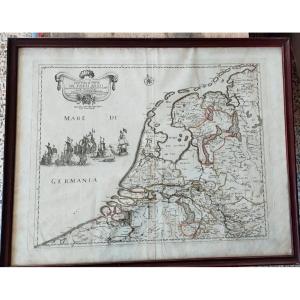
Original engraving paper from the time, framed, in excellent condition, size 53x42. . Decorative map of the Netherlands, published by Rossi in his Mercury geographical guide in all parts of the world [...]
The diocese of Montpellier divided into nine archpriests, Hubert Jaillot, 53x43cm. Engraving dedicated “Monseigneur Charles Joachim Colbert, bishop of Montpellier (nephew of the great Colbert...) and [...]
[MAP] - JAILLOT - Part of the bailiwick of Vosge or Mirecourt, in the duchy of Lorraine, part of the bailiwick of Bassigny or Barrois mouvant in the duchy of Bar divided by provost, offices, seneschal[...]
PERSOY, P.Britanniae, Amstedam, 1694. Richly enhanced print on paper. Rare map probably published in a composite atlas. It is dedicated to Jean SIX, Dutch poet and writer by Petrus PERSOY in the year [...]
Historical map of the Holy Roman Empire. by Matthew Setter. XVIII century. 57 X 50 cm and is accompanied by a large sheet lined with long historical and scholarly explanations. The two colorful of the[...]
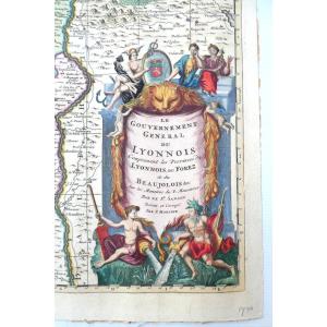
Map "Lyonnois, Burgundy, Franche Comté, Dauphiné, Provence" by JB Bourguignon d'Anville (1697-1782) geographer of the King Engraved by Jean-Baptiste Delahaye. Year of publication: 1719
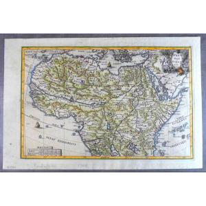
Beautiful map of the North of the African continent, due to the famous Jesuit cartographer Scherer, printed and nicely hand colored in Munich, who edited the Atlas Novus.
Nice cartridge with emblemat[...]
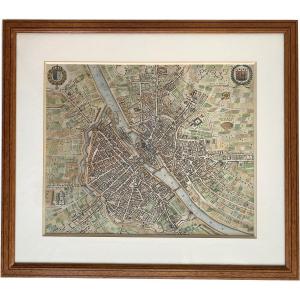
Matthaus MERIAN (1593-1650) (after)
Parys, Anno 1654
Enhanced engraving
Pitchwood frame
Plan facing north at bottom left, offering an unusual view of the city, with the Seine forming a diagona[...]
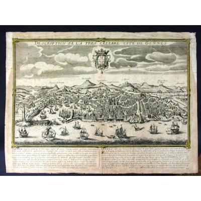
Epreuve originale gravée en 1645 sur 2 feuillets joints. Jean Boisseau éditeur.
Renfort de papier japon au dos des grandes marges bien conservées, fines traces de plis.
Bon état.
Format feuille : [...]
Jean Baptiste NOLIN (1686-1762) Cartographer.
GALLIAE CHRISTIANAE. PROVINCIA ECCLESIASTICA ARELATENSIS.
18th century map of the Camargue including the dioceses of Arles, Marseille, Toulon and the Pr[...]
Map from : Traité de la Police
In 1667, Lamoignon, first president of the Parliament of Paris, suggested to Nicolas de La Mare to write a book exposing the police methods applicable in a big city. L[...]
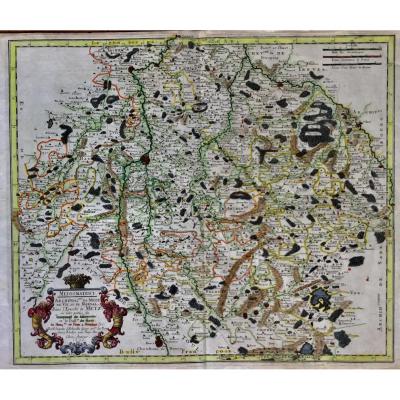
serious geographical map and dating from 1656 by Nicolas SANSON (1600-1667) titled: mediomatrici Archidiac of METZ of VIC and MARSAL in the eveche of METZ at the author 1656 in paris card named mediom[...]
Here is the beautiful celestial planisphere of Eimmart, one of the most sought after engravings in astronomy. Our engraving is identical to that of the National Library, same colors and dimensions, or[...]
Proantic uses a cookie to analyze traffic and improve its service by using Google Analytics. Data sent to Google Analytics (frequency of visits to the site and pages visited) are anonymous. No other cookie tracks your activity, your personal data is not collected. Thank you for helping us to have better understanding how Proantic is used.


 Le Magazine de PROANTIC
 TRÉSORS Magazine
 Rivista Artiquariato