Avec les ports de Port-Clos, Loguivy, Pontrieux, Lézardrieux.Epreuve originale réalisée en 1878.Impression en couleurs.Rousseurs claires éparses.Bon état.Format feuille : 65 x 49 cm.Original antique c[...]
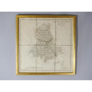
Framed map of the department of Haute Vienne 87 by AM Perrot and J Aupice printed in 1825 by the publisher Duprat Duverger. Originally folded map which was then flattened and framed. Gilded wooden fra[...]
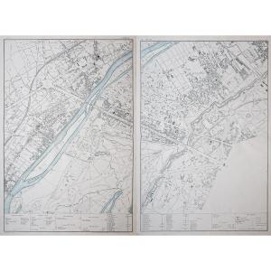
Epreuve originale réalisée en 1868.Limites colorées de l’époque, avec renvois des divers services municipaux.Très bon état.Format : 82 x 61,5 cm.Vous pouvez consulter l’ensemble
des cartes, livres et[...]
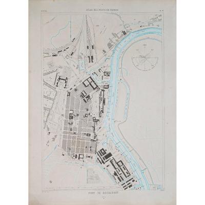
Carte gravée en 1889.Belle impression en couleurs.Rousseurs claires éparses.Bon état.Format feuille : 67 x 49 cm.Original antique chart of 1889.Rare collection illustrant les ports de France.Instituti[...]
Carte originale réalisée en 1838. Chez Firmin Didot éditeur.Carte entoilée d’époque en 18 parties sous reliure.Cartouche aquarellé.2 trous de vers dont un plus marqué dans la mer sous la Bretagne.Mors[...]
RAVENSTEIN (August) [Geographical Atlas for Primary Education] - 6 relief maps Set of 6 relief maps for educational use and for the visually impaired. The complete edition consisted of eight relief ma[...]
Antiquae and Novae map of Italy published in London in 1825. Entirely canvassed in two parts, North and South, this map is bilingual. The ancient places are associated with Italian names in order to g[...]
Rare 19th century map from the Atlas of the ports of France. "Map of Pénerf to Barre de Mont, mouth of the Loire 1895" with Noirmoutier, Le Croisic... Modern metal frame (101 cm x 71 cm) light oak tin[...]
Carte originale gravée en 1880.
Très bon état.
Format feuille : 35 x 27 cm.
Format gravure : 26,5 x 21 cm.
Original antique plan of 1880.
Blasons décoratifs de Philippe Auguste, Hôtel Vauvert (Lu[...]
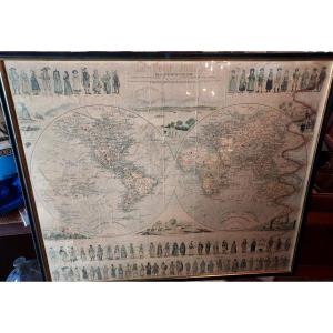
Tableau Sphéroïdal de la Terre ou Mappemonde en deux Hémisphères.
Grande épreuve originale réalisée en 1860. Garnier F.A cartographe.
Très belle impression en couleurs.
Infimes rousseurs.
Très bon[...]
Bouzigues, Balaruc-le-Vieux, Balaruc-les-bains.
Carte gravée en 1894.
Impression en couleurs.
Très bon état.
Format feuille : 66,5 x 49 cm.
Original antique chart of 1894.
Rare collection illust[...]
Epreuve originale réalisée en 1826.
Limites colorées de l’époque.
Excellent état
Format feuille : 51 x 41 cm.
Peu courante publication réalisée sous le règne de Charles X, illustrant les départem[...]
Epreuve originale réalisée en 1815. Charle auteur.
Quelques rousseurs claires.
Bon état.
Format feuille : 44 x 29 cm.
Vous pouvez consulter l’ensemble des cartes, livres et gravures disponibles [...]
Carte marine ancienne du port de Dunkerque
Grande épreuve originale réalisée en 1873.
Impression en couleurs.
Rousseurs claires dans les marges.
Bon état.
Format feuille : 95,5 x 66,5 cm.
Origin[...]
Epreuve originale réalisée en 1810. Publiée chez C. Smith.
Beaux coloris anciens.
Bon état.
Format feuille : 40 x 31,5 cm.
Format gravure : 38 x 30 cm.
Original antique map of 1810
Vous pouvez[...]
Epreuve originale réalisée en 1875.
Impression en couleurs.
Très bon état.
Format feuille : 65 x 49 cm.
Original antique chart of 1875.
Rare collection illustrant les ports de France.
Institutio[...]
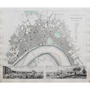
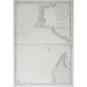
Très grande épreuve originale réalisée en 1893.
Impression en couleurs.
Très bon état.
Format feuille : 138 x 66,5 cm.
Original antique chart of 1893.
Rare collection illustrant les ports de Fran[...]
Epreuve originale réalisée en 1810.
Très bon état.
Format feuille : 23 x 30 cm.
Encadrés avec renvois situant les monuments, places, édifices et rues du quartier.
Vous pouvez consulter l’ensembl[...]
Great map
"L'EMPIRE FRANÇAISE et de L'ALLEMAGNE"
dated 1810
It is in excellent condition, with visible signs of aging.
DIMENSIONS Map: Width 102 cm - Height 76 cm
DIMENSIONS Frame: Width 108[...]
Carte originale gravée en 1860.
Beaux coloris aquarelle.
Rousseurs claires.
Très bon état.
Format feuille : 53 x 36 cm.
Format gravure : 44 x 32 cm.
Original antique map of 1860.
Célèbre éditio[...]
Epreuve originale réalisée en 1804. Joseph Roux cartographe.
Coloris aquarelle.
Très bon état.
Format feuille : 23,5 x 16,5 cm.
Format gravure : 21 x 14 cm.
Original antique map of 1804
Vous p[...]
Le dessin préparatoire de cette aquatinte à été réalisé lors du Voyage autour du monde à bord du navire La Favorite commandée par Cyrille Laplace en 1830 . Peu courant.
Laplace's journey. Aquatint en[...]
Epreuve originale réalisée en 1848. Editée à Edimbourg par Johnston.
Coloris aquarelle.
Mouillures claires et plis de papier ancien.
Bon état.
Format feuille : 68 x 55,5 cm.
Original antique map [...]
gravure de Lemercier tirée de l'atlas national français représentant le département français de l'Allier France milieru du XIX sec.
33 cm x 56 a encadrer
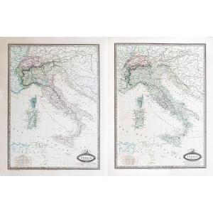
Italie, limites en 1859.
Italie, limites en 1861
2 épreuves originales réalisées en 1861. Garnier F.A cartographe.
Très belle impression en couleurs.
Infimes rousseurs.
Très bon état.
Formats fe[...]
Lithographie originale de 1870. Benoist dessinateur et lithographe.
Belle impression en couleurs.
Fines rousseurs du temps.
Très bon état.
Format feuille : 46 x 31 cm.
Vous pouvez consulter l’e[...]
Epreuve originale réalisée en 1832. J. Henshall graveur et Clarke dessinateur.
Fine consolidation dans la marge latérale droite n’atteignant pas la carte.
Bon état.
Format feuille : 41 x 34,5 cm.
[...]
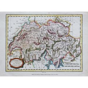
Switzerland with its subjects and allies from the best authorities.
Epreuve originale réalisée en 1807. J. Barlow graveur.
Coloris anciens.
2 rousseurs claires dans la marge supérieure n’atteignant[...]
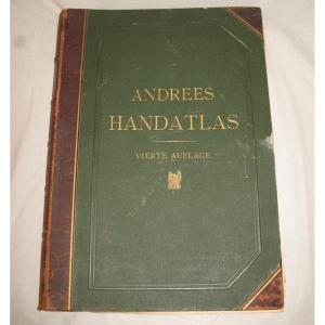
Handatlas de Andrees Collection of maps in German language dated 1899 Comprising 126 maps in plano and 137 side maps 4th edition by A. Scobel in Leipzig Drawing board type binding in strong cardboard [...]
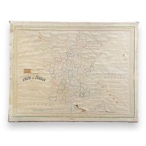
Map Of France By Augusta Delafont Embroidery On Silk On Frame Made in Providence Very beautiful piece mounted on frame We report a few accidents Free and insured shipping in mainland France
Epreuve originale réalisée en 1848. Editée à Edimbourg par William Blackwood.
Coloris aquarelle.
Très bon état.
Format feuille : 68 x 55,5 cm.
Original antique map of 1848.
Carte particulièrement[...]
Carte originale gravée en 1860.
Beaux coloris aquarelle.
Très bon état.
Format feuille : 53 x 36,5 cm.
Célèbre édition du milieu du 19ème siècle publiée rue Saint Jacques à Paris, illustrée de c[...]
Epreuve originale réalisée en 1812. Anville cartographe.
Limites colorées de l’époque.
Rousseurs dans la marge latérale gauche, loin de la carte.
Bon état.
Format feuille : 55 x 36 cm.
Format gra[...]
Carte originale gravée en 1860.
Beaux coloris aquarelle.
Très bon état.
Format feuille : 52,5 x 36 cm.
Célèbre édition du milieu du 19ème siècle publiée rue Saint Jacques à Paris, illustrée de c[...]
Old map "drawn up and engraved especially for the little journal according to the most recent documents" Very interesting map, a real document because it provides information on the costumes of the in[...]
Les Salettes, les Salins d’Hyères, Saint-Tropez, Sainte Maxime, Saint-Raphaël, Porquerolles, Port Cros.
Carte gravée en 1891.
Belle impression en couleurs.
Très bon état.
Format feuille : 66 x 49,[...]
Historical collection. Map of Belgium and Luxembourg dating from 1849 Free frame
Height: 35cm (25cm without frame)
Width: 40cm (31cm without frame)
As is
Same map available in 83x83cm
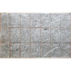
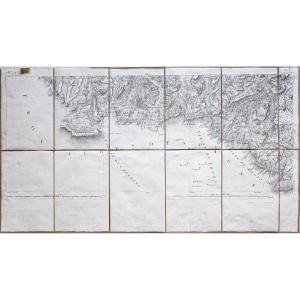
4 épreuves originales réalisées en 1867 au dépôt de la guerre, chez Andriveau Goujon.
Carte gravée sur 4 feuillets de 16 sections.
Entoilées d’époque.
Rousseurs sur la toile n’affectant pas les car[...]
Epreuve originale réalisée en 1852. Dépôt de la Guerre éditeur.
Coloris manuscrit.
Plan entoilé d’époque et monté en 21 sections.
Format feuille : 87,5 x 59,5 cm.
Format replié : 20 x 12,5 cm.
[...]
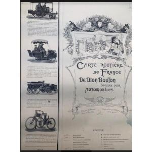
Map of France De Dion Bouton Speciale for motorists Edited by J. Barreau Paris 16 rue Littre Drawn and engraved by F.Vavasseur 82 rue Mazarine Scale 800.OOO e Imp E. Dufrenoy49 rue du Montparnasse Par[...]
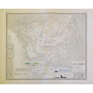
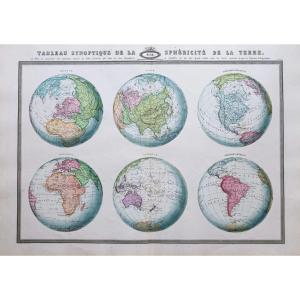
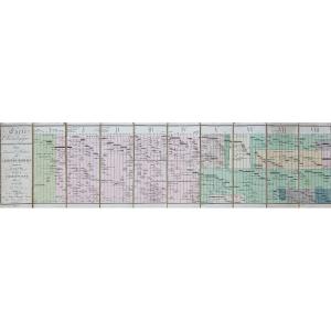
Tableau synoptique de la sphéricité de la Terre.
Grande épreuve originale réalisée en 1860. Garnier F.A cartographe.
Très belle impression en couleurs.
Infimes rousseurs.
Très bon état.
Format fe[...]
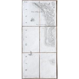
Ile d'Oléron – Maumusson – Cordouan – Cassini map no. 134 Original Cassini map from 1768. Published by Andriveau – Goujon around 1815. Period linen and mounted in 6 sections. Very good state. Sheet si[...]
Map of Catholic Missions in French Indo-China. Color map drawn up by Adrien Launay of the Society of Foreign Missions, according to official documents and information from missionaries. Dimensions: 87[...]
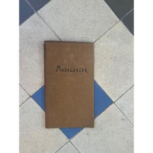
Old map of Madagascar 1885 Drawn from the documents of RP de la Vaissiere and MA GRANDIDIER Drawn and engraved by R.HAUSERMANN Dimension: 50 cm by 43 cm Presented nature in good condition as in the ph[...]
Epreuve originale de Cassini réalisée en 1779. Editée chez Picquet en 1815.
Entoilées d’époque et montées en 21 sections.
Une rousseur dans l'angle gauche de la marge supérieure.
Quelques forêts co[...]
Plan original réalisé en 1892. Paulin cartographe.
Belle impression en couleurs.
Entoilé d’époque et replié en 18 sections.
Très bon état.
Format : 73 x 57,5cm.
Plan en première édition. Légende [...]
Plan original réalisé en 1896. A. Kruger architecte de la ville.
Dressé sous l’administration de Monsieur Castets maire de la ville.
Entoilé d’époque, replié en 24 sections.
Trace de pli angulaire [...]
Carte originale éditée en 1808. Chez Arthus Bertrand.
Entoilée d’époque repliée en 8 sections.
Beaux coloris aquarelle.
Quelques plis angulaires sur les panneaux.
Bon état.
Format Carte : 81 x 30[...]
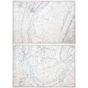
Suresnes – Saint Cloud.
Canton de Neuilly.
2 grandes cartes originales réalisées en 1874. Lefèvre géographe.
Coloris aquarelle dans la Seine.
Très bon état.
Format feuille : 95 x 64,5 cm.
Origin[...]
Rare geometric plan of the properties dependent on the castle of Grèzes located in the town of Carcassonne belonging to Mr Jean François Paul MARAVAL judge at the civil court of Carcassonne-Aude-dated[...]
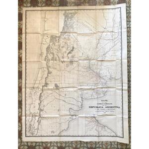
Map of Argentina 19th, 156 x 120, Mapa de Los Ferro Carriles, Republica Argentina y Los Paises limitrofes, compiled by Carlos Gordon 1889, duly stamped, very good condition, rare imperfections, canvas[...]
Carte originale levée en 1825 et gravée en 1831. Beautemps-Beaupré ingénieur hydrographe.
Infimes traces de rousseurs dans la marge droite. Très bon état.
Format feuille : 94,5 x 66,5 cm.
Original [...]
Canton de Neuilly.
2 grandes cartes originales éditées en 1874. Lefèvre cartographe.
Coloris aquarelle dans la Seine.
1 renfort au dos de la marge inférieure dans la carte 2.
Très bon état.
Forma[...]
Epreuve originale réalisée en 1849. Leménagev auteur.
Beaux coloris aquarelle.
Très bon état.
Format feuille : 45,5 x 35 cm.
Original antique plan of 1849.
Encart avec renvois de A à Z situant le[...]
Carte originale de Cassini réalisée en 1779-1781, éditée chez Andriveau – Goujon vers 1815.
Entoilée d’époque et montée en 12 sections.
Format feuille : 72,5 x 40,5 cm.
Format repliée : 20 x 13,5 c[...]
Original card engraved in 1860. Beautiful watercolor colors. Very good state. Sheet size: 53 x 36.5 cm. Famous mid-19th century edition published on rue Saint Jacques in Paris, illustrated with commen[...]
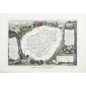
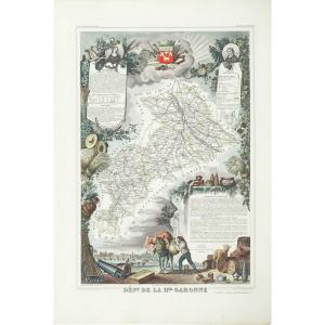
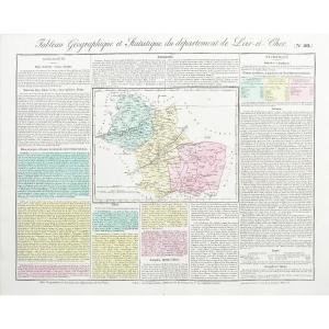
Epreuve originale réalisée en 1826.
Limites colorées de l’époque.
Excellent état
Format feuille : 51 x 41 cm.
Peu courante publication réalisée sous le règne de Charles X, illustrant les départem[...]
Canton de Neuilly.
Grande carte originale réalisée en 1874. Lefèvre cartographe.
Coloris aquarelle dans la Seine.
Très bon état.
Format feuille : 95 x 64,5 cm.
Original antique map of 1874.
Larg[...]
Carte originale éditée en 1885.
Belle impression en couleurs.
Petites rousseurs éparses. Infime pincement de papier d’origine dans les deux angles supérieurs.
Très bon état.
Format feuille : 65,5 [...]
Proantic uses a cookie to analyze traffic and improve its service by using Google Analytics. Data sent to Google Analytics (frequency of visits to the site and pages visited) are anonymous. No other cookie tracks your activity, your personal data is not collected. Thank you for helping us to have better understanding how Proantic is used.


 Le Magazine de PROANTIC
 TRÉSORS Magazine
 Rivista Artiquariato