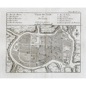
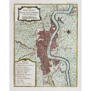
Epreuve originale réalisée en 1760. Bellin géographe.
Coloris aquarelle.
Rousseurs claires dans les marges.
Très bon état.
Format feuille : 48 x 34 cm.
Format gravure : 24 x 18 cm.
Original anti[...]
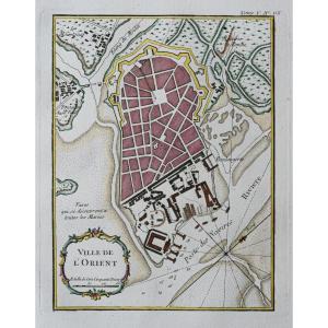
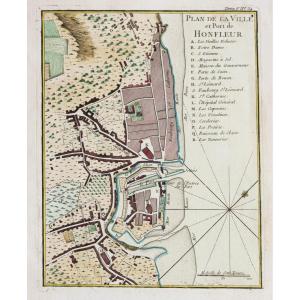
Epreuve originale réalisée en 1760. Bellin géographe.
Coloris aquarelle.
Rousseurs claires dans les marges.
Très bon état.
Format feuille : 33,5 x 24 cm.
Format gravure : 23 x 19 cm.
Original an[...]
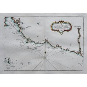
Epreuve originale réalisée en 1760. Bellin géographe.
Coloris aquarelle.
Rousseurs claires dans les marges.
Très bon état.
Format feuille : 47,5 x 34 cm.
Format gravure : 35 x 23,5 cm.
Original [...]
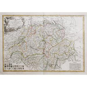
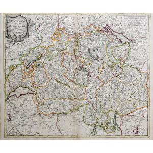
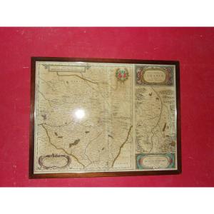
Divisée en ses 13 cantons et ses alliés.
Epreuve originale réalisée en 1782. Bonne cartographe.
Limites colorées à l’aquarelle.
Petits trous de ver près de Zurich. Restauration ancienne dans la mar[...]
Epreuve originale réalisée en 1705. Nicolas de Fer géographe.
Beaux coloris aquarelle.
Très bon état.
Format feuille : 40,5 x 27,5 cm.
Format gravure : 34,5 x 23,5 cm.
Original antique map of 170[...]
Plan of the town and suburbs of Bourges, capital of the province of Berri. Original proof made in 1705. Nicolas de Fer cartographer. 1 small wormhole under the title block. Good condition. Sheet size:[...]
Epreuve originale réalisée vers 1750. Anonyme.
Une partie de la marge latérale gauche rapportée anciennement.
1 pli ancien dans l’angle inférieur gauche.
Bon état.
Format feuille : 46 x 38 cm.
Fo[...]
Epreuve originale réalisée vers 1760.
Coloris aquarelle.
Rousseurs éparses.
Bon état.
Format feuille : 35 x 25 cm.
Format gravure : 22 x 19,5 cm.
Original antique chart of 1760
Vous pouvez co[...]
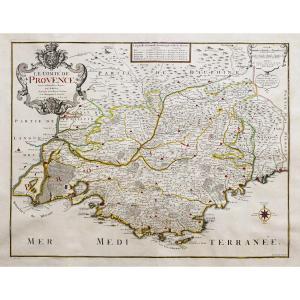
Epreuve originale gravée en 1750. Robert de Vaugondy cartographe.
Limites colorées de l’époque.
Légère oxydation classique dans les marges n’atteignant pas la carte.
Très bon état.
Format feuille [...]
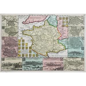
Grande épreuve originale réaliséeen 1720, datée 1780 lorsque Dezauche rachète les cuivres à la Maison Delisle.
Gravée sur 2 feuillets joints. Guillaume De L’Isle cartographe, Dezauche géographe succe[...]
Epreuve originale gravée en 1756. Vaugondy géographe.
Limites colorées de l’époque.
Rousseurs éparses dans les marges n’atteignant pas la carte.
Petits trous de vers dans l’angle inférieur gauche l[...]
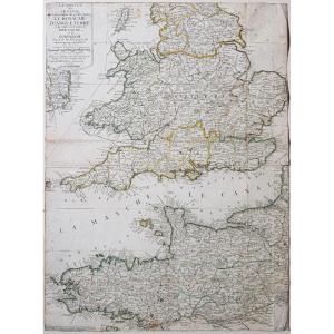
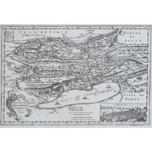
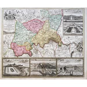
Epreuve originale réalisée en 1720. Bodenhr graveur.
Fines rousseurs et un trou ancien sur 2mm dans légende du tableau de gauche.
Etat correct.
Format feuille : 31 x 19,5 cm.
Format gravure : 26 x[...]
La Manche ou le Canal au septentrion duquel se trouve le Royaume d’Angleterre et au Midi les côtes de Bretagne et de Normandie.
Epreuve originale réalisée vers 1700. Nicolas de Fer cartographe.
Limi[...]
Epreuve originale de Cassini réalisée en 1764. Editée chez Auvray en 1790.
Entoilées d’époque et montées en 15 sections.
Beaux coloris anciens.
1 rousseur dans la mer.
Très bon état.
Format feuil[...]
Original map engraved in 1760. Bellin geographer. Watercolor colors. Fine light foxing in the margins not reaching the map. Very good state. Sheet size: 48.5 x 33.5 cm. Engraving format: 34 x 25 cm. O[...]
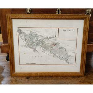
Lightly watercolored map from 1746 by Le Rouge, representing the Ile de Ré. Slight stains on the paper which do not affect the quality of this card. Pitchpin style oak frame with net 33 cm x 27 cm
Epreuve originale réalisée en 1708. Nicolas de Fer cartographe.
Limites colorées de l’époque.
Restauration d’un manque de papier sur 1 cm au niveau de la ville Le Tourrennet, avec légende manuscrite[...]
Map of the Canary Islands, with the island of Madeira and that of Porto Santo Color engraving after Rigobert Bonne engineer and hydrographer of the Navy 32 x 21 cm
Epreuve originale réalisée en 1750. Robert de Vaugondy cartographe.
Seconde édition de 1790.
Beaux coloris aquarelle.
Mouillure claire dans le bas des marges latérales n’atteignant pas la carte.
B[...]
Epreuve originale réalisée en 1747. De la Feuille éditeur.
Beaux coloris anciens.
1 rousseur dans l’encadré représentant la ville de Paris.
Très bon état.
Format feuille : 30 x 20,5 cm.
Format gr[...]
Original map engraved around 1750. Sauerbery engraver. Formerly lined on Japanese paper. Good condition. Sheet size: 36 x 24.5 cm. Engraving format: 33 x 22.5 cm. Original antique map around 1750. M[...]
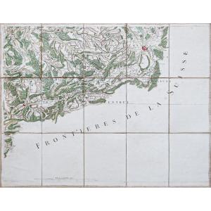
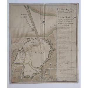
Old handwritten map (18th century): DUNKERQUE 1781, First Sheet of the Project - PLAN OF DUNKERQUE which indicates the Repairs proposed by the various Articles of the Project for 1781. Pen and ink was[...]
Epreuve originale réalisée en 1690. Vincenzo Coronelli cartographe.
Belle épreuve bien contrastée.
Format feuille : 66,5 x 49,5 cm.
Format gravure : 61 x 45,5 cm.
Original antique map of 1690.
Be[...]
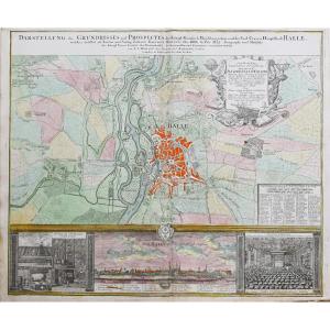
Epreuve originale réalisée vers 1720. Homann cartographe.
Très beaux coloris anciens.
2 oxydations dans la légende du panorama et au niveau de Diemnitz.
Bon état.
Format feuille : 61 x 51 cm.
For[...]
Epreuve originale réalisée vers 1720. Valck cartographe.
Limites colorées de l’époque.
Marge supérieure coupée au cuivre.
Oxydation au niveau du pli central.
Etat correct.
Format feuille : 61 x 5[...]
Original proof made around 1740. Covens et Mortier publishers. Guillaume DeLisle geographer. Colorful boundaries of the time. Beautiful old colors. 1 reinforcement in the upper margin at the title lev[...]
Epreuve originale réalisée vers 1720. P. Schenk auteur.
Limites colorées de l’époque.
2 renforts au dos de la carte dans l’angle inférieur gauche et pli central droit.
Bon état.
Format feuille : 5[...]
Interesting plan which shows the defenses and surroundings of the capital of the Habsburg Empire around 1742. The course of the Danube, which has not yet been tamed, with its numerous arms and islands[...]
Large épreuve originale réalisée en 1707. Hubert Jaillot cartographe.
Limites colorées de l’époque.
1 pincement ancien de papier dans l’angle supérieur gauche.
Très bon état.
Format feuille : 79 x[...]
Epreuve originale réalisée vers 1750. Bellin cartographe.
Rousseurs claires éparses dans les marges.
Coloris aquarelle.
Très bon état.
Format feuille : 34 x 25 cm.
Format cuivre : 23 x 18 cm.
Or[...]
Epreuve originale réalisée vers 1720. Baptist Homann cartographe.
Beaux coloris anciens.
Très bon état.
Format feuille : 63,5 x 51 cm.
Format gravure : 57 x 49,5 cm.
Original antique map of 1720.[...]
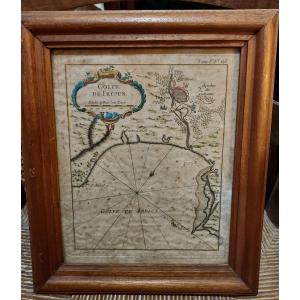
Beautiful 18th century maritime map representing the Gulf of Frejus. This engraving enhanced with gouache comes from a Maritime Atlas by Jacques Nicolas Bellin in 1764. Some foxing. Dimensions at sigh[...]
Epreuve originale réalisée vers 1720. Par Jaillot chez Mortier.
Limites colorées de l’époque.
Bon état général.
Format feuille : 92,5 x 60 cm.
Format gravure : 84 x 56,5 cm.
Original antique map [...]
Epreuve originale réalisée en 1764. Bellin cartographe.
Coloris aquarelle.
Très bon état.
Format feuille : 34 x 25 cm.
Format gravure : 23 x 18 cm.
Original antique map of 1764.
Carte particuliè[...]
Pair of maps of Europe 18th century
Cartographer R. Bonne "Orbis Vetus",
The world in antiquity
April 1781
Copper engraving Image 32 x 21 cm
Full page: 37.5 x 26.5 cm
Cartographer R. Bonne
"G[...]
Epreuves originales réalisées vers 1720. Pierre Mortier éditeur.
Beaux coloris aquarelle.
Fines traces de pliures au niveau du pli central.
Bon état.
Format feuille : 59,5 x 51 cm environ.
Collec[...]
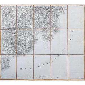
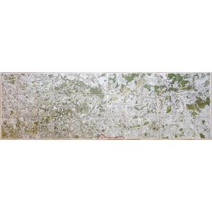
Epreuve originale de Cassini réalisée en 1780. Editée chez Picquet en 1815.
Entoilées d’époque et montées en 15 sections.
Tampon du bureau topographique au centre de la carte.
Très bon état.
Forma[...]
Epreuve originale réalisée en 1720. Sanson auteur et Mortier éditeur.
Limites colorées de l’époque.
Restauration dans le bas de la marge latérale gauche n’atteignant pas la carte.
Fine ondulation a[...]
Very beautiful watercolor map of the province of Limousin and the Limagne plain (Clermont-Ferrand); 18th century. Wooden frame. - External frame dimensions: 54 x 42 cms.
N°11 la Chatre & N°31 le Blanc, Châteauroux, Montmorillon.
Carte originale réalisée vers 1790. Piquet éditeur.
Double carte, entoilée d’époque et montée anciennement en 36 sections.
Beaux coloris a[...]
Epreuve originale réalisée vers 1750. Bellin cartographe.
Rousseurs claires éparses dans les marges.
Coloris aquarelle.
Très bon état.
Format feuille : 34 x 25 cm.
Format cuivre : 23 x 18,5 cm.
[...]
Epreuve originale réalisée en 1720. Homann cartographe.
Beaux coloris anciens.
Très bon état.
Format feuille : 62 x 50,5 cm.
Format gravure : 58,5 x 50 cm.
Original antique map of 1720.
Carte pa[...]
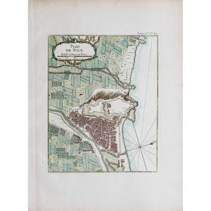
Epreuve originale réalisée vers 1760. Bellin cartographe.
Coloris aquarelle.
Très bon état.
Format feuille : 34 x 25 cm.
Format gravure : 24 x 19 cm.
Original antique map around 1760.
Echelle de[...]
Epreuve originale réalisée en 1764. Bellin cartographe.
Coloris aquarelle.
Très bon état.
Format feuille : 31,5 x 22 cm.
Format gravure : 24 x 19 cm.
Original antique map of 1764.
Carte particul[...]
Carte des provinces de Tabasco, Chiapas, Vera Paz, Guatemala, Honduras et Yucatan.
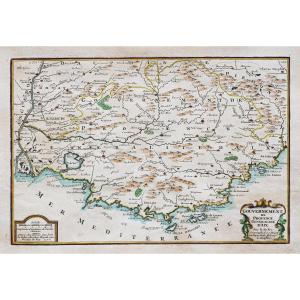
Epreuve originale réalisée vers 1750. Bellin cartographe.
Coloris aquarelle.
Fines rousseurs claires éparses.
Trè[...]
Grande épreuve originale réalisée vers 1700. Valck cartographe.
Limites colorées de l’époque.
1 renfort dans la marge latérale droite et un dans la marge inférieure au dos de la carte.
1 rousseur d[...]
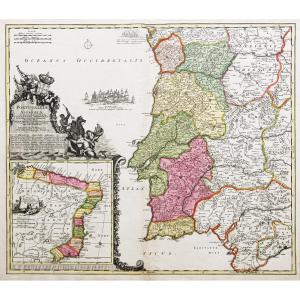
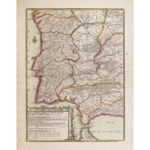
Les frontières de l’Espagne et Portugal.
Epreuve originale réalisée en 1790. Desnos géographe.
2 rousseurs dans les marges latérales droite et gauche n’atteignant pas la carte.
Bon état.
Format fe[...]
Partie septentrionale de l’Evêché de Chartres.
Epreuve originale réalisée en 1701. Jaillot cartographe.
Belle impression bien contrastée.
Petite faiblesse dans le bas de la marge latérale droite n’[...]
Epreuve originale réalisée vers 1680. De Witt auteur.
Beaux coloris anciens.
Très bon état.
Format feuille : 61,5 x 51,5 cm.
Format gravure : 60 x 47 cm.
Original antique map around 1680.
Très b[...]
Epreuve originale réalisée en 1764. Bellin cartographe.
Coloris aquarelle.
Très bon état.
Format feuille : 33,5 x 24,5 cm.
Format gravure : 24 x 18,5 cm.
Original antique map of 1764.
Plan parti[...]
Original map engraved in 1750. Bellin cartographer. Very good state. Watercolor colors. Sheet size: 22.5 x 18.5 cm. Original antique map of 1750. You can consult all the maps and engravings available [...]
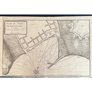
Plan of the town and mole of Agde with the Fort Brescou.
7th Chart of the coast of France from the Iles de Bretah to Port Louis.
Epreuve originale réalisée en 1759. J. Jefferys graveur.
Beaux color[...]
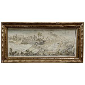
Beautiful and large drawing, with watercolor highlights.
Signed and located by hand at the bottom in the margin
Very meticulous and highly technical work.
Above, write, "View of the bridge of Chat[...]
Carte originale gravée en 1787. Villaret & Philippe cartographes.
Cartouche et rose des vents aquarellés.
Très bon état.
Format feuille : 50 x 33 cm.
Format gravure : 41 x 29 cm.
Original antique[...]
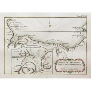
Côte de Normandie depuis le Havre jusqu’à la Hougue.
Epreuve originale réalisée en 1764. Bellin cartographe.
Coloris aquarelle.
Fines rousseurs dans les marges.
Bon état.
Format feuille : 47,5 x [...]
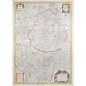
Epreuve originale réalisée en 1753. Robert de Vaugondy géographes, père et fils.
Limites colorées de l’époque.
Très bon état.
Format feuille : 75 x 56 cm.
Format gravure : 62,5 x 49,5 cm.
Origina[...]
Epreuve originale réalisée en 1753. Robert de Vaugondy cartographe.
rousseurs dans les marges n’atteignant pas la carte.
Limites colorées de l’époque.
Bon état.
Format feuille : 74,5 x 58 cm.
For[...]
Proantic uses a cookie to analyze traffic and improve its service by using Google Analytics. Data sent to Google Analytics (frequency of visits to the site and pages visited) are anonymous. No other cookie tracks your activity, your personal data is not collected. Thank you for helping us to have better understanding how Proantic is used.


 Le Magazine de PROANTIC
 TRÉSORS Magazine
 Rivista Artiquariato