Epreuve originale réalisée vers 1590. Braun et Hogenberg auteurs.Beaux coloris aquarelle.1 rousseur claire près de Notre Dame des Tables.Marge latérale droite rapportée anciennement.Bon état.Format fe[...]
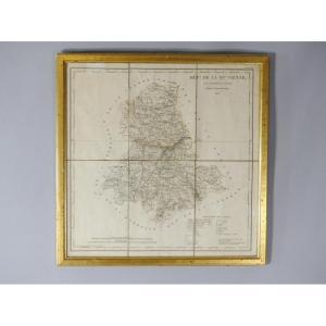
Framed map of the department of Haute Vienne 87 by AM Perrot and J Aupice printed in 1825 by the publisher Duprat Duverger. Originally folded map which was then flattened and framed. Gilded wooden fra[...]
Epreuve originale réalisée en 1868.Limites colorées de l’époque, avec renvois des divers services municipaux.Très bon état.Format : 82 x 61,5 cm.Vous pouvez consulter l’ensemble
des cartes, livres et[...]
Carte gravée en 1889.Belle impression en couleurs.Rousseurs claires éparses.Bon état.Format feuille : 67 x 49 cm.Original antique chart of 1889.Rare collection illustrant les ports de France.Instituti[...]
Map of Italy drawn up by the cartographer Eustache Hérisson (1759-1816), pupil and student of Rigobert Bonne (1727-1795), map published by Basset in 1805. Good condition, traces of folding, see photos[...]
Old and very interesting map of the city of Bordeaux and its suburbs in 1775, under King Louis XVI after the major works of the intendants. Very detailed map, locating the main streets, avenues, squar[...]
Epreuve originale réalisée en 1632. Jean Leclerc éditeur.Rousseurs claires dans les marges.Coloris aquarelle.Texte en vieux Français au verso.Bon état.Format feuille : 55 x 40 cm.Format gravure : 49,5[...]
Carte originale réalisée en 1838. Chez Firmin Didot éditeur.Carte entoilée d’époque en 18 parties sous reliure.Cartouche aquarellé.2 trous de vers dont un plus marqué dans la mer sous la Bretagne.Mors[...]
Engraving GOVERNMENT OF PROUINS (PROVINS - 77) RARE Burin engraving on steel, by Christophe TASSIN, born in the early 1600s and died in 1660, in France, also known as Nicolas Tassin, Christophe Nicola[...]
Nice relief map of Switzerland by JDShneiter dated 1850. Please note: The map is worn (see photos). Map dimensions: 45.5cm x 61.5cm Frame dimensions: 54cm x 70cm
Epreuve originale réalisée en 1704. Nicolas de Fer géographe.
Fines rousseurs claires éparses.
Très bon état.
Format feuille : 40 x 28 cm.
Format gravure : 36,5 x 26,5 cm.
Original antique map of[...]
Epreuve originale réalisée en 1632. Maurice Bouguereau & Jean Leclerc éditeurs.
Rousseurs dans les 2 angles supérieurs n’atteignant pas la carte.
Texte en vieux Français au verso.
Etat correct.
Fo[...]
Embroidered map representing the department of Drôme, made at the beginning of the 19th century. The composition follows a decorative grammar specific to this period, close to the ornaments visible on[...]
Map of the Diocese of Castres, dedicated to Messire Augustin de Maupéou, Advisor to the King in his councils, Bishop of Castres, by his very humble and very obedient servant HUBERT JAILLOT, Geographer[...]
"The Dauphiné, divided into its principal parts" drawn up by Hubert Jaillot (Paris 1632-Paris 1712).
Copper engraving. Printed in 1718. At Jaillot Paris. Sheet
53 x 74 cm
“Tabula Delphinatus et vicinarum regionnum” by Guillaume de L’Isle (Paris 1675-Paris1726). Copper engraving. In Amsterdam Covens and Mortier. Early 18th century. Sheet
54.5 x 65 cm
"Tabula Delphinatus vulgo, The General Government of DAUPHINÉ… Jo Baptista Homanno…" Edited by Johann HOMANN (1663-1724) German Geographer and Cartographer.
Copper engraving.
Printed in Nuremberg. E[...]
Large map of Japan produced by the Navy's Hydraugraphic Service in 1906. This is the 1915 edition. This map represents exactly: "East Coast of Asia. Islands and Seas of Japan. Yellow Sea". The map is [...]
MAP AND GENERAL DESCRIPTION OF LANGUEDOC Drawn up by Jean Cavalier d'Agde, geographer to the king in 1621. In 1627, while he was 1st Consul of Agde, he married Dame d'Estienne at Notre-Dame du Grau. I[...]
Epreuve originale réalisée en 1705. Nicolas De Fer cartographe.
Fines traces d’encre sur le bord de la marge latérale droite.
Très bon état.
Format feuille : 40 x 28 cm.
Original antique map of 17[...]
Large and rare copperplate engraving, on thick paper, from the work Grandes routes d'Angleterre, d'Ecosse et d'Irlande (G. Robert de Vaugondy, 1757, in Paris). after Abraham Wolfgangk (1634 – 1694) Pr[...]
Epreuve originale réalisée en 1762. Sieur Janvier géographe.
Beaux coloris anciens.
Très bon état.
Format feuille : 51 x 37 cm.
Format gravure : 47,5 x 32 cm.
Original antique map of 1762.
Carte[...]
RAVENSTEIN (August) [Geographical Atlas for Primary Education] - 6 relief maps Set of 6 relief maps for educational use and for the visually impaired. The complete edition consisted of eight relief ma[...]
Epreuve originale réalisée en 1614.
Mouillures dans les angles inférieurs et supérieurs de la gravure, s’arrêtant au raz du cuivre.
Bon état.
Format feuille : 43,5 x 36,5 cm.
Format gravure : 36 x[...]
Epreuve originale réalisée en 1777. Antonio Zatta cartographe.
Coloris anciens.
Oxydation ancienne de 1 centimètre dans le haut de la marge supérieure, loin du sujet.
Bon état.
Format feuille : 51[...]
Carte du Diocèse d’Uzès, dressée sur les lieux par le Sr Gautier, ingénieur, architecte et inspecteurs des Ponts et Chaussées.
Grande épreuve entoilée d’époque, réalisée vers 1720. Nolin géographe.
[...]
Epreuve originale réalisée en 1630. Mercator/ Hondius cartographes.
Texte explicatif en latin au verso.
Beaux coloris anciens.
Fines rousseurs dans les marges.
Très bon état.
Format feuille : 57,[...]
Et des mers voisines.
Epreuve originale réalisée en 1763. Bellin cartographe.
Coloris aquarelle.
Fines rousseurs claires éparses.
Très bon état.
Format feuille : 48 x 34 cm.
Format gravure : 47 [...]
Imperium Caroli magni, occidentis imperatoris complectens universam Galliam, in Hispania quidquid à Pyrenaeis jugis occurrit ad Iberum et Rubricatum usque fluvios, cum Balearibus insulis, in Italiã qu[...]
From the NEW GEOGRAPHY and STATISTICS of FRANCE. By J. HENRY. Each plate is presented in the same way: Famous person, presentation of the department, a part on the remarks and curiosities of the place[...]
Pretty little original polychrome engraving, representing the department of HAUT-RHIN with a small comment on the number of inhabitants, surface area… Hand-watercoloured. Dimension(s): Frame: Height. [...]
Original steel engraving with a burin. Engraved by Tassin (Christophe), often mistakenly confused with Nicolas Tassin, he was in reality the King's engineer-geographer. Although his dates of birth and[...]
Beautiful map of the Provence region taken by Pierre-Jean de Bompar in 1591 and published in 1594 for his highness Charles-Emmanuel of Savoy (1562-1630). Please note: -The presence of stains and holes[...]
Epreuve originale réalisée en 1705. Nicolas De Fer cartographe.
Limites colorées de l’époque.
Rousseurs claires dans les marges n’atteignant par la carte.
Bon état.
Format feuille : 40 x 28 cm.
O[...]
Epreuve originale réalisée en 1764. Bellin cartographe.
Coloris aquarelle.
Rousseurs claires éparses.
Très bon état.
Format feuille : 48 x 34 cm.
Format gravure : 30,5 x 25 cm.
Original antique [...]
Set of 3 road maps of the departments of Algiers, Constantine and Oran. General Government of Algiers - Directorate of Agriculture and Colonization - Cartographic Service - Map of Communication Routes[...]
Antiquae and Novae map of Italy published in London in 1825. Entirely canvassed in two parts, North and South, this map is bilingual. The ancient places are associated with Italian names in order to g[...]
Map "MOLUCCAE INSULAE" By Willem Janseoon BLAEU, describing the Moluccas Islands. Circa 1640 Total dimensions of the plate: 52.5 x 63 cm Dimensions of the map: 37 x 48.5 cm Comes from an atlas. Note t[...]
Rare 18th century map from the second edition of Neptune François representing the "Map of the Costes de Poitou d'Aunis and Saintonge from the Isle of Noirmoustier to the mouth of the Bordeaux river" [...]
Rare 19th century map from the Atlas of the ports of France. "Map of Pénerf to Barre de Mont, mouth of the Loire 1895" with Noirmoutier, Le Croisic... Modern metal frame (101 cm x 71 cm) light oak tin[...]
Epreuve originale réalisée en 1785. Bonne cartographe.
Beaux coloris aquarelle de l’époque.
Petit frottement de papier dans la partie gauche de la mer.
Très bon état.
Format feuille : 49,5 x 38,5 [...]
View of the city of Grenoble in a "cavalier plan", that is to say seen from above. The original of this representation, made by F. Hogenberg, dates from 1588. This one is a 17th century copy, which wa[...]
Carte originale gravée en 1880.
Très bon état.
Format feuille : 35 x 27 cm.
Format gravure : 26,5 x 21 cm.
Original antique plan of 1880.
Blasons décoratifs de Philippe Auguste, Hôtel Vauvert (Lu[...]
Epreuve originale réalisée vers 1760. Bellin cartographe.
Coloris aquarelle.
1 mouillure claire dans le haut de la marge supérieure loin de la carte.
Bon état.
Format feuille : 48 x 33,5 cm.
Form[...]
Epreuve originale réalisée en 1732. Homann héritier éditeur.
Coloris anciens.
Très bon état.
Format feuille : 62,5 x 54 cm.
Format gravure : 52 x 44 cm.
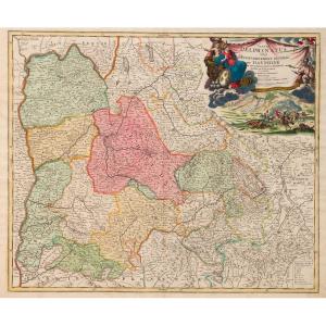
Belle carte de l’Île de la Corse. Un large[...]
Epreuve originale réalisée vers 1780. Bonne cartographe.
Beaux coloris aquarelle.
Très bon état.
Format feuille : 36 x 24 cm.
Format gravure : 35 x 22,5 cm
Original antique map around 1780
Vou[...]
Divisé en sept principales parties, et subdivisé en soixante six Royaumes.
Epreuve originale réalisée vers 1750. Seconde édition de 1790.
Robert de Vaugondy géographe.
Coloris aquarelle.
Très bon [...]
Carte des sept Îles à la côte de Bretagne.
Plan de l’Île aux Moines et ses mouillages.
Epreuve originale réalisée en 1764. Bellin cartographe.
Coloris aquarelle.
Très bon état.
Format feuille : 3[...]
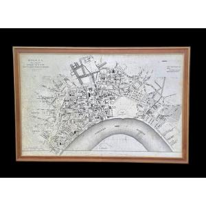
ESNAULT, Jacques (1739-1812) § RAPILLY, Michel (1740-1797), Engravers-publishers, Booksellers and Print Dealers in Paris - "New Road Map of the City and Suburbs of Paris (..) from the year 1786". Pres[...]
Page 67 of a work from the beginning of the 18th century "Genesis"
Sheet 54 X 39 cm plate 19 X 30 cm
Very good condition
Date: 1704 or 1724
"Adjoining the Historical Table of the First Age of th[...]
Epreuve originale réalisée vers 1640. Jansson éditeur.
Beaux coloris anciens.
Texte explicatif en gothique au verso.
Renfort ancien au dos du pli central dans la marge inférieure.
Bon état.
Forma[...]
Plan of Montauban Attack by Louis 13 in 1621 The siege of Montauban pitted, from August to November 1621, the royal armies commanded by the King of France Louis XIII against the Protestants of Montaub[...]
Carte originale gravée en 1860.
Beaux coloris aquarelle.
Rousseurs claires.
Très bon état.
Format feuille : 52 x 37,5 cm.
Format gravure : 45 x 32 cm.
Original antique map of 1860.
Célèbre édit[...]
Tableau Sphéroïdal de la Terre ou Mappemonde en deux Hémisphères.
Grande épreuve originale réalisée en 1860. Garnier F.A cartographe.
Très belle impression en couleurs.
Infimes rousseurs.
Très bon[...]
Proantic uses a cookie to analyze traffic and improve its service by using Google Analytics. Data sent to Google Analytics (frequency of visits to the site and pages visited) are anonymous. No other cookie tracks your activity, your personal data is not collected. Thank you for helping us to have better understanding how Proantic is used.


 Le Magazine de PROANTIC
 TRÉSORS Magazine
 Rivista Artiquariato