Epreuve originale réalisée en 1705. Nicolas De Fer cartographe.
Limites colorées de l’époque.
Rousseurs claires dans les marges n’atteignant par la carte.
Bon état.
Format feuille : 40 x 28 cm.
O[...]
Epreuve originale réalisée en 1764. Bellin cartographe.
Coloris aquarelle.
Rousseurs claires éparses.
Très bon état.
Format feuille : 48 x 34 cm.
Format gravure : 30,5 x 25 cm.
Original antique [...]
Epreuve originale réalisée vers 1700. Van Keulen auteur.
Limites colorées de l’époque.
Rousseurs éparses.
Bon état.
Format feuille : 61,5 x 53,5 cm.
Format gravure : 60 x 52 cm.
Original antique[...]
Rare 18th century map from the second edition of Neptune François representing the "Map of the Costes de Poitou d'Aunis and Saintonge from the Isle of Noirmoustier to the mouth of the Bordeaux river" [...]
Epreuve originale réalisée en 1785. Bonne cartographe.
Beaux coloris aquarelle de l’époque.
Petit frottement de papier dans la partie gauche de la mer.
Très bon état.
Format feuille : 49,5 x 38,5 [...]
Epreuve originale réalisée vers 1760. Bellin cartographe.
Coloris aquarelle.
1 mouillure claire dans le haut de la marge supérieure loin de la carte.
Bon état.
Format feuille : 48 x 33,5 cm.
Form[...]
Epreuve originale réalisée en 1732. Homann héritier éditeur.
Coloris anciens.
Très bon état.
Format feuille : 62,5 x 54 cm.
Format gravure : 52 x 44 cm.
Belle carte de l’Île de la Corse. Un large[...]
Epreuve originale réalisée vers 1780. Bonne cartographe.
Beaux coloris aquarelle.
Très bon état.
Format feuille : 36 x 24 cm.
Format gravure : 35 x 22,5 cm
Original antique map around 1780
Vou[...]
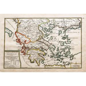
Divisé en sept principales parties, et subdivisé en soixante six Royaumes.
Epreuve originale réalisée vers 1750. Seconde édition de 1790.
Robert de Vaugondy géographe.
Coloris aquarelle.
Très bon [...]
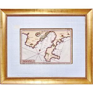
Carte des sept Îles à la côte de Bretagne.
Plan de l’Île aux Moines et ses mouillages.
Epreuve originale réalisée en 1764. Bellin cartographe.
Coloris aquarelle.
Très bon état.
Format feuille : 3[...]
ESNAULT, Jacques (1739-1812) § RAPILLY, Michel (1740-1797), Engravers-publishers, Booksellers and Print Dealers in Paris - "New Road Map of the City and Suburbs of Paris (..) from the year 1786". Pres[...]
Page 67 of a work from the beginning of the 18th century "Genesis"
Sheet 54 X 39 cm plate 19 X 30 cm
Very good condition
Date: 1704 or 1724
"Adjoining the Historical Table of the First Age of th[...]
Carte originale gravée en 1860.
Beaux coloris aquarelle.
Rousseurs claires.
Très bon état.
Format feuille : 52 x 37,5 cm.
Format gravure : 45 x 32 cm.
Original antique map of 1860.
Célèbre édit[...]
Epreuve originale réalisée en 1783. D’Anville cartographe.
Rousseurs claires dans les marges.
Coloris aquarelle.
Très bon état.
Format feuille : 55 x 54 cm.
Format gravure : 46,5 x 38,5 cm.
Orig[...]
Epreuve originale réalisée vers 1792. Raymond géographe.
Coloris aquarelle.
Très bon état.
Format feuille : 41,5 x 33 cm.
Format gravure : 38,5 x 31 cm.
Original antique map of 1792.
L’une des p[...]
preuve originale réalisée vers 1760. Bellin cartographe.
Coloris aquarelle.
Fines rousseurs claires éparses.
Très bon état.
Format feuille : 47 x 33 cm.
Format gravure : 33 x 22 cm.
Original ant[...]
Epreuve originale réalisée vers 1760. Bellin cartographe.
Coloris aquarelle.
Fines rousseurs claires éparses.
Bon état.
Belle épreuve sur grand papier.
Format feuille : 33,5 x 25 cm.
Format grav[...]
Epreuve originale réalisée en 1782. Pierre-François Tardieu graveur.
Très beaux coloris anciens.
Fines rousseurs claires dans les marges n’atteignant pas le plan.
Excellent état.
Format feuille : [...]
Original proof made around 1760. Bellin cartographer. Watercolor colors. Scattered light fine foxing. Good condition. Sheet size: 33.5 x 25 cm. Engraving size: 23.5 x 18.5 cm. Original antique map aro[...]
Family tree map Prince of Poland (18th century) Paper map representing the family tree of the Origin of the Princes and Dukes of the Family of Piaste and Origin of the First Princes and Dukes of Polan[...]
Map of Switzerland in 1783, double-page engraving, map by Jaillot, ordinary cartographer of the King (Louis XVI), good condition, period coloring, a small reinforcement (photo), traces of folding.
Map of the northern part of the United States, map by Pierre François Tardieu from 1792, published in Paris in the Atlas of Mentelle & Chanlaire in 1806. Double-page engraving, original coloring, all [...]
Original copperplate print, by JEFFERYS Thomas Hand-watercoloured. Dimension(s): Frame: Length 47.6 cm - Height 35.2 cm, condition(s): PERFECT CONDITION, Period: MID-18th century, Frame: CURRENT - Gol[...]
Epreuve originale réalisée en 1782. Antonio Zatta éditeur.
Beaux coloris aquarelle.
Légères rousseurs et marques du temps dans les marges.
Bon état.
Format feuille : 55,5 x 41,5 cm.
Format gravur[...]
Carte des Alpes Maritimes – Menton – Monaco – Nice
Epreuve originale réalisée en 1758. Villaret auteur.
Très bon état.
Format feuille : 67,5 x 46 cm.
Parfaite Impression cartographiant la vallée d[...]
Rare and Large 18th Century Map "The Western Coast of Louisiana and The Coast of New Leon" This is the 1794 edition by Laurie & Witthe of Thomas Jeffrys' map. Period proof Good general condition, some[...]
Map of the city of Tornea, engraved by Delahaye.
Tears in the margins, small foxing.
54 x 35 cm
Sent by Colissimo with signature.
Careful packaging.
Unless otherwise indicated, the objects pu[...]
Large 18th Century Map - Saint Lucia "St. Lucia done from Surveys and Observations made by the English whilst in their Possession" This is the 1794 edition by Laurie & Witthe of Thomas Jeffrys' map. P[...]
Large 18th Century Map - Barbados "Barbadoes, Surveyed by William Mayo, Engraved and Improved by Thomas Jefferys, Geographer to the King" This is the 1794 edition by Laurie & Witthe of Thomas Jeffrys'[...]
Epreuve originale réalisée en 1702. Nicolas de Fer cartographe.
Limites colorées de l’époque.
2 rousseurs dans la marge latérale droite loin du sujet.
Bon état.
Format feuille : 40 x 29 cm.
Forma[...]
Epreuve réalisée en 1780. Moithey graveur.
Rousseurs claires au niveau du pli central et dans les mages.
Bon état.
Format feuille : 69 x 53 cm.
Format gravure : 48 x 39,5 cm.
Original antique eng[...]
Engraving of Southern Saxony, that is to say the duchy, the electorate, and the joint principality of the dukes of Saxony.
This 18th century engraving more broadly represents South-East Germany and[...]
Epreuve originale réalisée vers 1760. Bellin cartographe.
Coloris aquarelle.
Fines rousseurs claires éparses.
Très bon état.
Format feuille : 47 x 33 cm.
Format gravure : 36 x 21 cm.
Original an[...]
Diocèse de Montpellier.
Epreuve originale réalisée vers 1721-1741.
Carel Allard cartographe. Chez Mortier.
Limites colorées de l’époque.
Mouillures claires dans la marge supérieure loin de la cart[...]
Epreuve originale réalisée en 1757. Le Rouge cartographe.
Beaux coloris aquarelle.
Infimes rousseurs du temps dans les marges.
Très bon état.
Format feuille : 38,5 x 25 cm.
Format gravure : 32 x [...]
Epreuve originale réalisée vers 1760. Bellin cartographe.
Coloris aquarelle.
Fines rousseurs claires éparses.
Très bon état.
Format feuille : 47 x 33 cm.
Format gravure : 33 x 21 cm.
Original an[...]
This rare and beautiful large animated marine map of Galleons with watercolor highlights represents the particular map of the surroundings of Abbeville Montreuil with the mouths of the Somme, Autie an[...]
Epreuve originale réalisée vers 1730. Liebaux graveur.
Limites colorées de l’époque.
Très bon état.
Format feuille : 73 x 52 cm
Format gravure : 65 x 49 cm.
Original antique map around 1730
Cart[...]
Epreuve originale réalisée en 1705. Nicolas De Fer cartographe.
Rousseurs claires dans la marge latérale gauche.
Bon état.
Format feuille : 40 x 28 cm.
Original antique map of 1705.
Ile, rocher, [...]
Epreuve originale réalisée en 1705. Nicolas De Fer cartographe.
Limites colorées de l’époque.
Très bon état.
Format feuille : 40 x 28 cm.
Original antique map of 1705.
Gouvernement général de Bre[...]
Epreuve originale réalisée en 1705. Nicolas De Fer cartographe.
Limites colorées de l’époque.
Fines rousseurs dans les marges n’atteignant pas la carte.
Bon état.
Format feuille : 40 x 28 cm.
Ori[...]
Partie nord des cantons de Berne et de fribourg, les cantons de Lucer, de Soleurre…
Epreuve originale réalisée en 1717. Jaillot géographe du Roi Louis XIV auteur.
Limites colorées de l’époque.
Bon [...]
Map of the Benelux region dating from the 1720s, produced by Iohanne Baptista Homanno
Under glass
Length (with/without frame): approx. 71 / 58cm
Width (with/without frame): approx. 63.5 / 50cm
[...]
-Ornamental cartridge with coat of arms. - List of battalions and squadrons at the headquarters of Lille. Plan of the city of Lille, France invested by the Haut-Allies under the command of HH Prince E[...]
Epreuve originale réalisée en 1758. Bellin cartographe.
Beaux coloris aquarelle.
Fines rousseurs claires éparses.
Bon état.
Format feuille : 33 x 25 cm.
Format gravure : 32 x 22 cm.
Original ant[...]
Epreuve originale réalisée vers 1760. Bellin cartographe.
Coloris aquarelle.
Fines rousseurs claires éparses.
Bon état.
Format feuille : 33,5 x 25 cm.
Format gravure : 23,5 x 18,5 cm.
Original a[...]
Epreuve originale réalisée en 1702. Nicolas de Fer graveur.
1 rousseur près du trait de cuivre dans la marge latérale gauche et 1 petit trou de ver dans la marge inférieure loin du sujet.
Bon état.
[...]
Grand plan original réalisé en 1724. Editée par Demortain à Paris.
Beaux coloris aquarelle.
Rousseurs claires près du mur du grand parc.
Très bon état.
Format feuille : 63 x 49 cm.
Format gravure[...]
Epreuve originale réalisée en 1764. Bellin cartographe.
Coloris aquarelle.
Rousseurs claires éparses.
Très bon état.
Format feuille : 54 x 33,5 cm.
Format gravure : 51,5 x 25 cm.
Original antiqu[...]
Original engraving on steel with a chisel and watermarked laid paper. Engraved by ROUX Antoine or Joseph Ange Antoine, (French -1765-1835). Marine painter. Hand watercolored. Dimensions: High. 29.5 cm[...]
Beautiful engraving of the city of Leiden in the Netherlands enhanced with watercolor 18th Century Very good original condition Engraving dimensions: 29.5 cm x 18.5 cm Dimensions with its frame: 36 cm[...]
Original engraving on steel with a chisel. Engraved by JEFFERYS Thomas (1719 - 1771) - ENGLISH School - Engraver, son of a cutler. He became a cartographer around 1744. Bankrupt in 1766. Dimension(s):[...]
Map of Asia, 2nd part
Second part of the map of Asia containing China and part of Tartary, India beyond the Ganges, the Isles of Sumatra, Java, Borneo, Moluccas, Philippines, and Japan.
Published un[...]
Map of Asia, 1st part
First part of the map of Asia containing Turkey, Arabia, Persia, India below the Ganges and Tartary which borders Persia and India.
Published under the auspices of Monsignor th[...]
Denmark and Sweden
18th c. map
dedicated to her majesty the King of Sweden, Gots and Vandals
by Guillaume Delisle, 1st geographer of the King, member of the Royal Academy of Sciences
completed by [...]
Proantic uses a cookie to analyze traffic and improve its service by using Google Analytics. Data sent to Google Analytics (frequency of visits to the site and pages visited) are anonymous. No other cookie tracks your activity, your personal data is not collected. Thank you for helping us to have better understanding how Proantic is used.


 Le Magazine de PROANTIC
 TRÉSORS Magazine
 Rivista Artiquariato