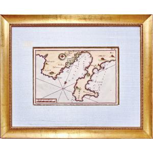
Original engraving on steel with a chisel and watermarked laid paper. Engraved by ROUX Antoine or Joseph Ange Antoine, (French -1765-1835). Marine painter. Hand watercolored. Dimensions: High. 29.5 cm[...]
Beautiful engraving of the city of Leiden in the Netherlands enhanced with watercolor 18th Century Very good original condition Engraving dimensions: 29.5 cm x 18.5 cm Dimensions with its frame: 36 cm[...]
Original engraving on steel with a chisel. Engraved by JEFFERYS Thomas (1719 - 1771) - ENGLISH School - Engraver, son of a cutler. He became a cartographer around 1744. Bankrupt in 1766. Dimension(s):[...]
Map of Asia, 2nd part
Second part of the map of Asia containing China and part of Tartary, India beyond the Ganges, the Isles of Sumatra, Java, Borneo, Moluccas, Philippines, and Japan.
Published un[...]
Map of Asia, 1st part
First part of the map of Asia containing Turkey, Arabia, Persia, India below the Ganges and Tartary which borders Persia and India.
Published under the auspices of Monsignor th[...]
Denmark and Sweden
18th c. map
dedicated to her majesty the King of Sweden, Gots and Vandals
by Guillaume Delisle, 1st geographer of the King, member of the Royal Academy of Sciences
completed by [...]
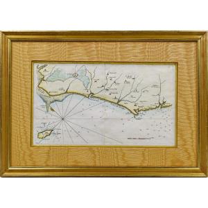
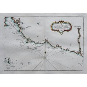
RARE NAVY MAP of VENDÉE - No. 27 - BEAUVOIR - L'ISLE D'YEU - SAINT HILAIRE - LES SABLES D'OLONNE - SAINT NICOLAS - Ep. 18th Original proof made in 1757 by Georges Louis Le ROUGE cartographer. Taken fr[...]
Original proof engraved in 1730. Mortier publisher. Colorful boundaries of the time. Oxidation in the right lateral margin not reaching the card. Good condition. Sheet size: 77.5 x 53.5 cm. Engraving [...]
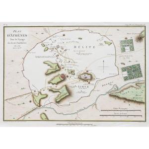
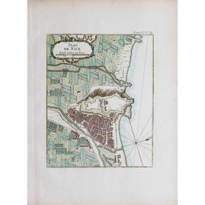
Epreuve originale réalisée en 1784. Tardieu graveur.
Beaux coloris aquarelle.
Très bon état.
Format feuille : 37,5 x 25,5 cm.
Format gravure : 32,5 x 21,5 cm.
Original antique plan of 1784
Vou[...]
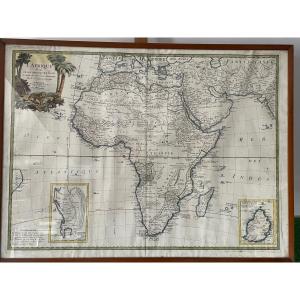
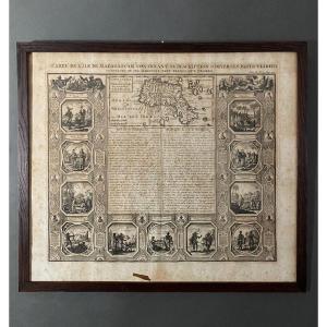
VERY BEAUTIFUL MAP OF AFRICA FROM THE 18TH PERIOD, 1753, AT THE BOTTOM RIGHT THE SPECIAL MAP OF ISLE DE FRANCE DRAWED UP BY THE ABBÉ DE LA CAILLE IN 1753, VERY FRESH, THE PHOTOS WITH THE GLASS ARE SLI[...]
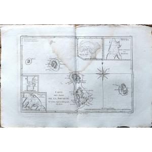
Marine map from the "Encyclopedic Atlas, containing ancient geography, and some maps on the geography of the Middle Ages, modern geography, and maps relating to physical geography", Paris, Hôtel de Th[...]
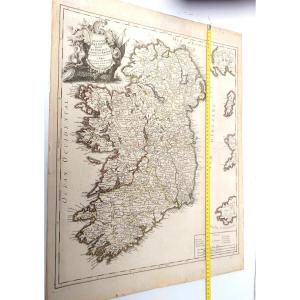
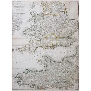
Beautiful large map : Kingdom of Ireland divided into provinces, counties and baronies, by Le Rouge, Georges-Louis (1712-1790). Cartographer, Edition date: 1745.
Decorated on top right with engraved [...]
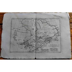
Original proof made in 1780 by Rigober BONNE cartographer, engraved on copper by André. From the Atlas of all the known parts of the terrestrial globe, drawn up for the Philosophical and Political His[...]
Marine map from the "Encyclopedic Atlas, containing ancient geography, and some maps on the geography of the Middle Ages, modern geography, and maps relating to physical geography", Paris, Hôtel de Th[...]
Epreuve originale réalisée en 1764. Bellin cartographe.
Coloris aquarelle.
Rousseurs claires dans les marges n’atteignant pas la carte.
Bon état.
Format feuille : 34 x 25,5 cm.
Format gravure : 2[...]
Grande Carta Corografica degli Stati di S.M. Re di Sardegna del 1772 di Stagnon e Borgonio
Large and Rare Chorographic Map of the States of H.M. the King of Sardinia in 1683 corrected and augmented[...]
Epreuve originale réalisée en 1764. Bellin géographe.
Coloris aquarelle.
Rousseurs claires dans les marges.
Très bon état.
Format feuille : 34 x 24,5 cm.
Format gravure : 23 x 18 cm.
Original an[...]
This map is from the 18th century, no doubt about it. It is beautifully made. Unfortunately, we report numerous traces of humidity and spots of freckles, the card is a little warped at the bottom, a s[...]
Epreuve originale réalisée en 1760. Bellin géographe.
Coloris aquarelle.
Rousseurs claires dans les marges.
Très bon état.
Format feuille : 48 x 34 cm.
Format gravure : 24 x 18 cm.
Original anti[...]
Epreuve originale réalisée en 1760. Bellin géographe.
Coloris aquarelle.
Rousseurs claires dans les marges.
Très bon état.
Format feuille : 33,5 x 24 cm.
Format gravure : 23 x 19 cm.
Original an[...]
Epreuve originale réalisée en 1760. Bellin géographe.
Coloris aquarelle.
Rousseurs claires dans les marges.
Très bon état.
Format feuille : 47,5 x 34 cm.
Format gravure : 35 x 23,5 cm.
Original [...]
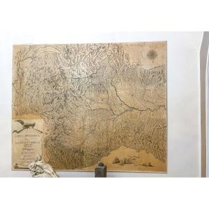
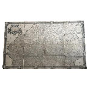
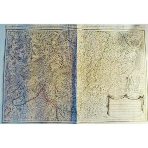
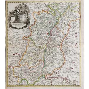
Huge 18th Century Map (1730) Of The Pyrenees Mountains And Part Of The Kingdoms Of France & Spain By Antoine Coquart (16..-17..) and Roussel (king's engineer, 16..-1733) Canvased at the Bel period con[...]
État : Excellent, la feuille a été doublée, ce qui la rendu solide. Les couleurs d’époque sont fraîches.
(Pour le texte suivant, je me suis largement inspiré d’une traduction d’un texte de Curtis Wri[...]
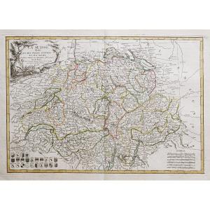
Divisée en ses 13 cantons et ses alliés.
Epreuve originale réalisée en 1782. Bonne cartographe.
Limites colorées à l’aquarelle.
Petits trous de ver près de Zurich. Restauration ancienne dans la mar[...]
Epreuve originale réalisée en 1705. Nicolas de Fer géographe.
Beaux coloris aquarelle.
Très bon état.
Format feuille : 40,5 x 27,5 cm.
Format gravure : 34,5 x 23,5 cm.
Original antique map of 170[...]
Plan of the town and suburbs of Bourges, capital of the province of Berri. Original proof made in 1705. Nicolas de Fer cartographer. 1 small wormhole under the title block. Good condition. Sheet size:[...]
Epreuve originale réalisée vers 1750. Anonyme.
Une partie de la marge latérale gauche rapportée anciennement.
1 pli ancien dans l’angle inférieur gauche.
Bon état.
Format feuille : 46 x 38 cm.
Fo[...]
Epreuve originale réalisée vers 1760.
Coloris aquarelle.
Rousseurs éparses.
Bon état.
Format feuille : 35 x 25 cm.
Format gravure : 22 x 19,5 cm.
Original antique chart of 1760
Vous pouvez co[...]
Epreuve originale gravée en 1750. Robert de Vaugondy cartographe.
Limites colorées de l’époque.
Légère oxydation classique dans les marges n’atteignant pas la carte.
Très bon état.
Format feuille [...]
Grande épreuve originale réaliséeen 1720, datée 1780 lorsque Dezauche rachète les cuivres à la Maison Delisle.
Gravée sur 2 feuillets joints. Guillaume De L’Isle cartographe, Dezauche géographe succe[...]
Epreuve originale gravée en 1756. Vaugondy géographe.
Limites colorées de l’époque.
Rousseurs éparses dans les marges n’atteignant pas la carte.
Petits trous de vers dans l’angle inférieur gauche l[...]
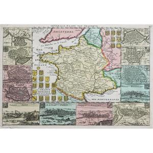
Epreuve originale réalisée en 1720. Bodenhr graveur.
Fines rousseurs et un trou ancien sur 2mm dans légende du tableau de gauche.
Etat correct.
Format feuille : 31 x 19,5 cm.
Format gravure : 26 x[...]
La Manche ou le Canal au septentrion duquel se trouve le Royaume d’Angleterre et au Midi les côtes de Bretagne et de Normandie.
Epreuve originale réalisée vers 1700. Nicolas de Fer cartographe.
Limi[...]
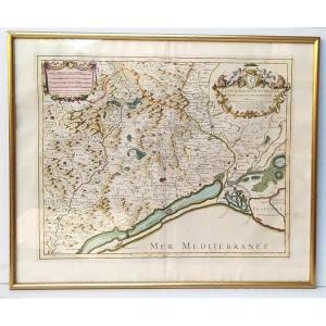
The diocese of Montpellier divided into nine archpriests, Hubert Jaillot, 53x43cm. Engraving dedicated “Monseigneur Charles Joachim Colbert, bishop of Montpellier (nephew of the great Colbert...) and [...]
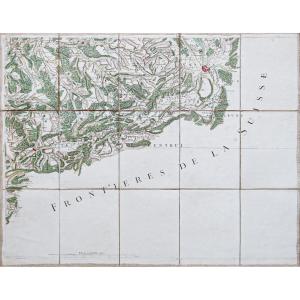
Epreuve originale de Cassini réalisée en 1764. Editée chez Auvray en 1790.
Entoilées d’époque et montées en 15 sections.
Beaux coloris anciens.
1 rousseur dans la mer.
Très bon état.
Format feuil[...]
Original map engraved in 1760. Bellin geographer. Watercolor colors. Fine light foxing in the margins not reaching the map. Very good state. Sheet size: 48.5 x 33.5 cm. Engraving format: 34 x 25 cm. O[...]
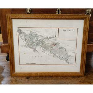
Lightly watercolored map from 1746 by Le Rouge, representing the Ile de Ré. Slight stains on the paper which do not affect the quality of this card. Pitchpin style oak frame with net 33 cm x 27 cm
Epreuve originale réalisée en 1708. Nicolas de Fer cartographe.
Limites colorées de l’époque.
Restauration d’un manque de papier sur 1 cm au niveau de la ville Le Tourrennet, avec légende manuscrite[...]
Map of the Canary Islands, with the island of Madeira and that of Porto Santo Color engraving after Rigobert Bonne engineer and hydrographer of the Navy 32 x 21 cm
Epreuve originale réalisée en 1750. Robert de Vaugondy cartographe.
Seconde édition de 1790.
Beaux coloris aquarelle.
Mouillure claire dans le bas des marges latérales n’atteignant pas la carte.
B[...]
Epreuve originale réalisée en 1747. De la Feuille éditeur.
Beaux coloris anciens.
1 rousseur dans l’encadré représentant la ville de Paris.
Très bon état.
Format feuille : 30 x 20,5 cm.
Format gr[...]
Original map engraved around 1750. Sauerbery engraver. Formerly lined on Japanese paper. Good condition. Sheet size: 36 x 24.5 cm. Engraving format: 33 x 22.5 cm. Original antique map around 1750. M[...]
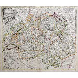
[MAP] - JAILLOT - Part of the bailiwick of Vosge or Mirecourt, in the duchy of Lorraine, part of the bailiwick of Bassigny or Barrois mouvant in the duchy of Bar divided by provost, offices, seneschal[...]
[MAP] - JAILLOT - Les Prévotez, offices, senehaussee and county, which are part of the bailiwicks of Vosge or Mirecourt and Nancy, in the duchy of Lorraine, the adjacent lands of Épinal, Chaté and the[...]
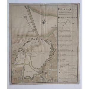
Old handwritten map (18th century): DUNKERQUE 1781, First Sheet of the Project - PLAN OF DUNKERQUE which indicates the Repairs proposed by the various Articles of the Project for 1781. Pen and ink was[...]
Epreuve originale réalisée en 1690. Vincenzo Coronelli cartographe.
Belle épreuve bien contrastée.
Format feuille : 66,5 x 49,5 cm.
Format gravure : 61 x 45,5 cm.
Original antique map of 1690.
Be[...]
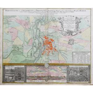
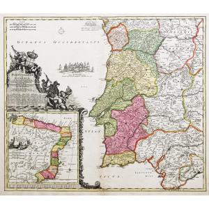
Epreuve originale réalisée vers 1720. Homann cartographe.
Très beaux coloris anciens.
2 oxydations dans la légende du panorama et au niveau de Diemnitz.
Bon état.
Format feuille : 61 x 51 cm.
For[...]
Epreuve originale réalisée vers 1720. Valck cartographe.
Limites colorées de l’époque.
Marge supérieure coupée au cuivre.
Oxydation au niveau du pli central.
Etat correct.
Format feuille : 61 x 5[...]
Original proof made around 1740. Covens et Mortier publishers. Guillaume DeLisle geographer. Colorful boundaries of the time. Beautiful old colors. 1 reinforcement in the upper margin at the title lev[...]
Epreuve originale réalisée vers 1720. P. Schenk auteur.
Limites colorées de l’époque.
2 renforts au dos de la carte dans l’angle inférieur gauche et pli central droit.
Bon état.
Format feuille : 5[...]
Interesting plan which shows the defenses and surroundings of the capital of the Habsburg Empire around 1742. The course of the Danube, which has not yet been tamed, with its numerous arms and islands[...]
Large épreuve originale réalisée en 1707. Hubert Jaillot cartographe.
Limites colorées de l’époque.
1 pincement ancien de papier dans l’angle supérieur gauche.
Très bon état.
Format feuille : 79 x[...]
Epreuve originale réalisée vers 1750. Bellin cartographe.
Rousseurs claires éparses dans les marges.
Coloris aquarelle.
Très bon état.
Format feuille : 34 x 25 cm.
Format cuivre : 23 x 18 cm.
Or[...]
Epreuve originale réalisée vers 1720. Baptist Homann cartographe.
Beaux coloris anciens.
Très bon état.
Format feuille : 63,5 x 51 cm.
Format gravure : 57 x 49,5 cm.
Original antique map of 1720.[...]
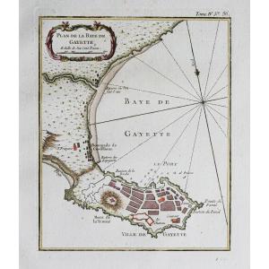
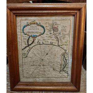
Beautiful 18th century maritime map representing the Gulf of Frejus. This engraving enhanced with gouache comes from a Maritime Atlas by Jacques Nicolas Bellin in 1764. Some foxing. Dimensions at sigh[...]
Epreuve originale réalisée vers 1720. Par Jaillot chez Mortier.
Limites colorées de l’époque.
Bon état général.
Format feuille : 92,5 x 60 cm.
Format gravure : 84 x 56,5 cm.
Original antique map [...]
Epreuve originale réalisée en 1764. Bellin cartographe.
Coloris aquarelle.
Très bon état.
Format feuille : 34 x 25 cm.
Format gravure : 23 x 18 cm.
Original antique map of 1764.
Carte particuliè[...]
Pair of maps of Europe 18th century
Cartographer R. Bonne "Orbis Vetus",
The world in antiquity
April 1781
Copper engraving Image 32 x 21 cm
Full page: 37.5 x 26.5 cm
Cartographer R. Bonne
"G[...]
plan of the city and suburb of Paris 1788 with all its additions and the new enclosure map mounted on canvas in 24 sections allegory of MONCEAU with street references. In Paris at Mondhare and Jean ru[...]
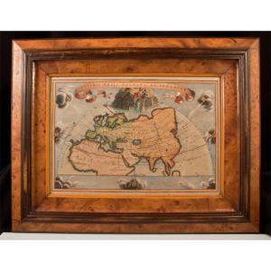
18th century engraving Veteris Orbis Climata Ex Strabone Walnut burr frame dimensions 46.8 cm x 36.7 cm View 32 cm x 22 cm Very good condition. Price nonnegotiable. Payment by check or bank transfer. [...]
Proantic uses a cookie to analyze traffic and improve its service by using Google Analytics. Data sent to Google Analytics (frequency of visits to the site and pages visited) are anonymous. No other cookie tracks your activity, your personal data is not collected. Thank you for helping us to have better understanding how Proantic is used.


 Le Magazine de PROANTIC
 TRÉSORS Magazine
 Rivista Artiquariato